 |
Click on HOME to return back |
Click on the images below for larger ones |
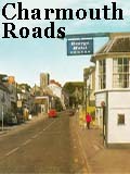
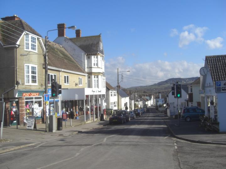
THE ROADS OF CHARMOUTH |
|
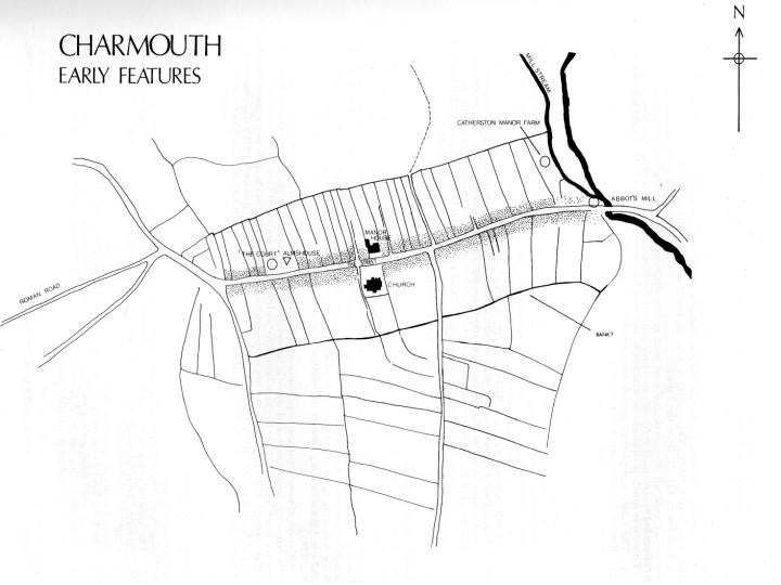
For nearly 2000 years Charmouth has existed along "The Street". Originally a Roman Road forming part of the Ackling Dyke from Dorchester to Exeter. After a period of decline it was improved by the Abbots of Forde who were to own the village for 4 centuries and attempt to create a Borough there, with burgage plots of half acre extending back from the Street to the North and South. The road had several hostelries along it which continued to operate after the dissolution of the Abbey in 1539. By the 18th century a number of Turnpike Trusts were set up in the area and the village benefited with the improved roads which bought many coaches through it en route from London to Exeter. In time the village grew along the axis of The Street and originally Sea Lane and later Higher Sea Lane gave access to the coast and in time were built along themselves. A history of the development of these roads can be seen by scrolling down. If you click on the thumbnail images at the side they will link to larger pictures. |
|
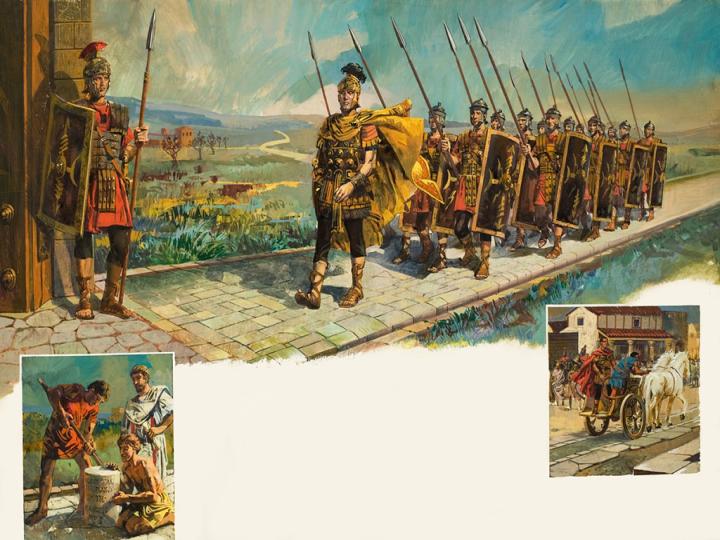
The illustration gives one an idea of how Charmouth may have looked nearly 2000 years ago when the Roman Road linking Dorchester with Exeter would have passed through it following the route of the present day Street. There are still discoveries to be made by the archaeologists to substantiate this completely, but the recent excavation of a section of it nearby at Hogchester Farm adds to our knowledge. Further evidence of Roman settlement in the area was found at Holcombe in Uplyme where a Romano British farm was revealed.
|
1 |
|
|
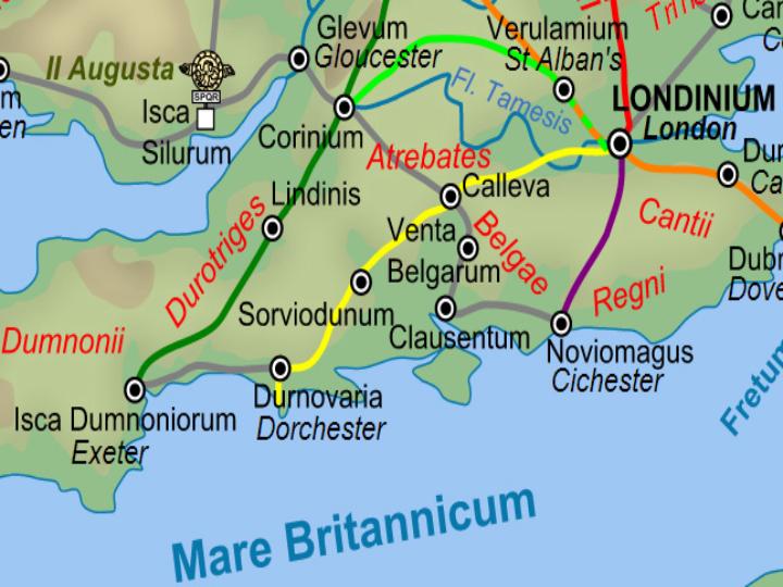
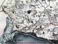
This map which can be seen on Wikipedia shows the network of Roman roads in southern England most of which were centred on London as they do today. In Britain, as in other provinces, the Romans constructed a comprehensive network of paved trunk roads during their four centuries of occupation whose primary function was to allow the rapid movement of troops.
Pre-roman Britons used mainly unpaved trackways running along elevated ridges of hills. An important ancient trackway from Devon ran east from Lambert's Castle to the Salisbury Plain and onwards. This track never fell below a height of four hundred feet except when crossing the valley of the Stour and was known as the Old Northern Trackway.
|
2 |
|
|
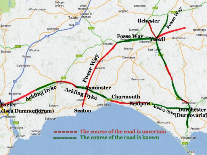
This present day map shows roughly the two main roman roads near to Charmouth. The Fosse Way marked a diagonal route from Lincoln to a port near Seaton and went though Axminster roughly paralleling the Cotswolds and then making use of the Axe valley.
The Ackling Dyke is the name generally given for the road that linked Exeter and Salisbury, via Dorchester, which was probably built sometime during the period 55 60AD. Those coloured red are for uncertain stretches. It has been suggested that the old road forked at the top of the hill through Charmouth, one branch running on to Exeter by way of Lyme Regis and the mouth of the Axe, and the other up Fern Hill and over Penn Cross to reach Exeter by Axminster and Honiton. The latter is generally accepted as the main route. Both these lines continued as main roads until comparatively recently, but Lyme Regis is now approached from Charmouth by what is a combination of them. The Old Lyme Road is still known as the Roman Road to this day.
|
3 |
|
|
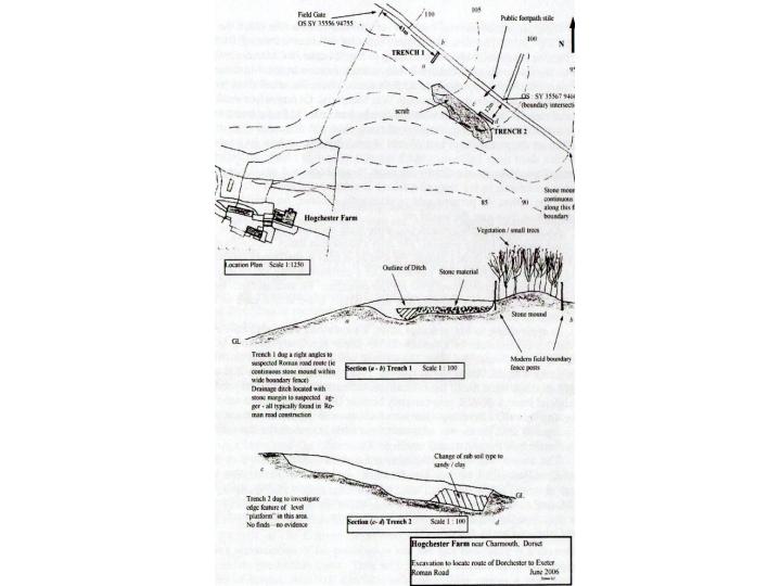
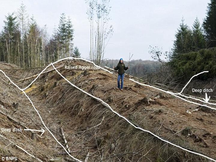
This illustration is from the Autumn 2006 Village Echo published by the Pavey Group from an article by Bill Putnam. A excavation was carried out I June of that year north of Hogchester Farm to find out if the Roman Road could be seen under a hedge climbing Thistle Hill, near Charmouth. As the plan and sections reveal, the dig exposed the east/west orientation of the probable Ackling Dyke (Dorchester Exeter Roman Road).
|
4 |
|
|
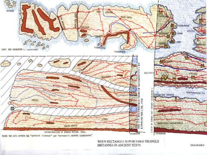
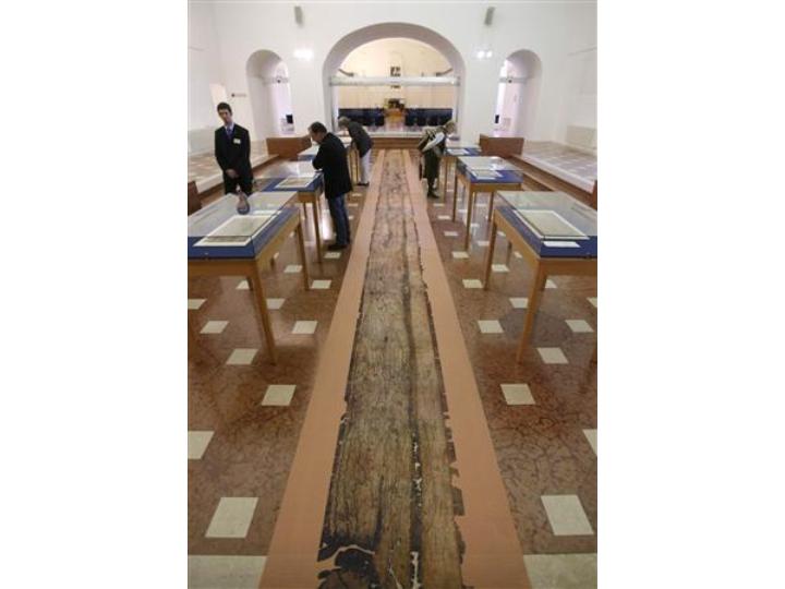
Amazingly there exists today in the Hapsburg library in Vienna a direct link with our Street. It is the Tabula Peutingeriana map which shows the road network in the Roman Empire. The original map (of which this is a unique copy) was last revised in the fourth or early fifth century. The parchment scroll, made in the Middle Ages, is the only surviving copy of a road map from the late Roman Empire.The document, which is almost seven metres long, shows the network of main Roman roads from Spain to India.
It is thought to be the distant descendant of the one prepared under the direction of Marcus Agrippa,a friend of Augustus. After Agrippa's death, the map was engraved on marble and placed in the Porticus Vipsaniae in Rome. It is a very schematic map: the land masses are distorted, especially in the east-west direction. The map shows many Roman settlements, the roads connecting them, rivers, mountains, forests and seas. The distances between the settlements are also given.
Unfortunately a section which would have covered the British Isles is missing. But the shaded area covering our region can be seen on the illustration showing Salisbury and Exeter with the road connecting them.The remainder of the map is a recreation made by experts as to how it way have looked if complete.
|
5 |
|
|
The Map rolled out showing its considerable length.
|
6 |
|
|
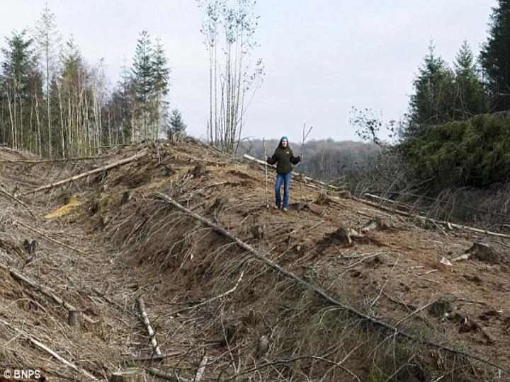
To help visualise the appearance of the Roman road we are fortunate in that 2 years ago a section to the east of Dorchester was found by the Forestry Commission, acting on advice from English Heritage expert Peter Addison whilst clearing the Norway spruce fir trees in Puddletown Forest. It is half-mile long and 15ft-high as is shown in the accompanying photograph.
|
|
|
|
The section uncovered was built from gravel and is amazingly well-preserved thanks to never having been under the plough and later covered with a dense pine wood . It is thought the road would have been made from layers of gravel and the fact it still exists is testimony to the skills of the builders.
There is a central cobbled street ' , which would have been used for rapid troop movements, and outer droving ' roads for livestock, as well as ditches for water drainage.
|
|
|
|
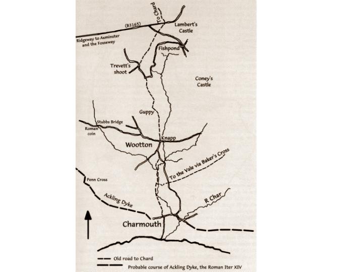
From Charmouth there were at least two routes into the interior. One, less direct is from Newlands by Bellair and Berne Farm, that is to say the present road from Charmouth to Whitechurch Canonicorum. The other is marked by the present road from Charmouth to Wootton Fitzpaine by the west side of Catherston and Knapp Farm. It now stops at the farm but formerly continued north by Guppy and Wootton Hill, where it is again a road, and this was in fact once the shortest route from the coast to Chard.
Ronald Good in his book Old Roads of Dorset , details an ancient track running from Charmouth along the existing footpath ( Barr`s lane) to Wootton, then passing Knapp Farm and continuing north to Guppy and Wootton Hill before joining the B3165 road and then on to Hawkchurch. This route was considered the shortest way from Charmouth to Chard for hundreds of years.
The Map shown comes from Wodetone A history of Wootton Fitzpaine by Guy Bryan.
|
|
|
|
There is now a big jump in our knowledge of the Street in Charmouth after the Romans left in the early 400 ' s A.D. Their roads often served as property boundaries. Hedges grew up along them. When the parishes were first laid out in the 700 ' s 800 ' s these hedges sometimes became parish boundaries and remain so today. The road from Dorchester borough boundary to Eggardon is wholly such a boundary. For about a mile east from Charmouth to the top of Stonebarrow Hill a boundary may follow the line of the Roman road.
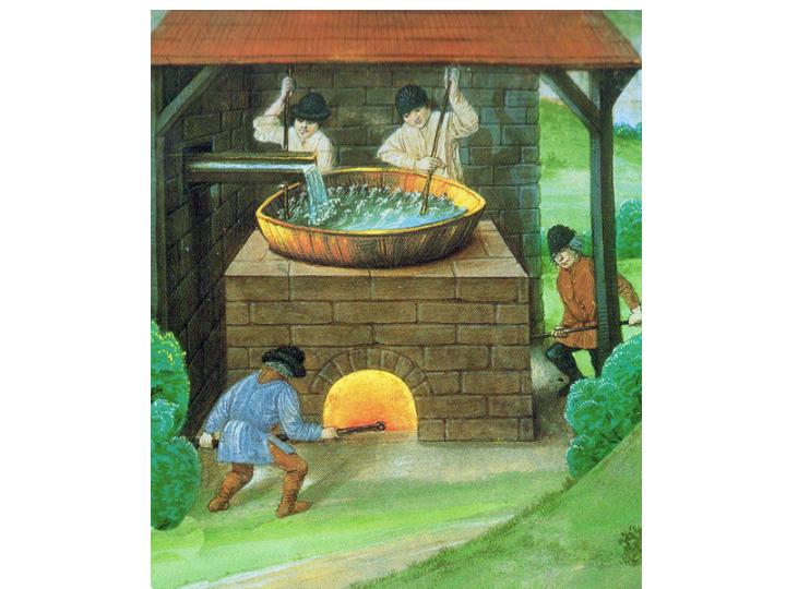
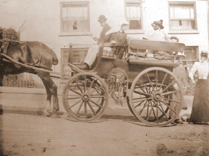
The prosperity of Charmouth for many centuries was based on Salt. For the Domesday Book for 1086 shows the population included 16 Salt workers who were employed boiling the Sea Water in large shallow open Lead Pans until the water evaporated and the salt removed. This was not unusual as the industry could be found all along our coast and would have originated with the Romans. In the same year, Lyme Regis had 27 workers and it h as been suggested that the four estates that comprised Lyme in 1086 may have been derived from a single Roman salt-producing estate based on Holcombe Villa at Uplyme. Indeed the earliest document relating to the town is in 774AD when Cynewulf, the West Saxon King granted land on the west bank of the River Lym to Sherbourne Abbey in order that Salt may be boiled there. The main use of the salt was to preserve food for the winter months and was one of the first traded products and would have been carried by packhorse or boat.
|
|
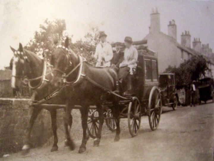
|
|
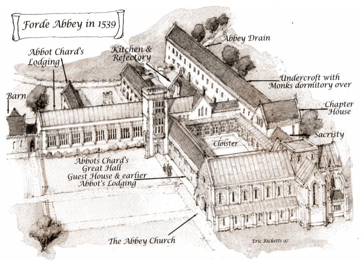
No single owner of Charmouth had more impact on its history than Forde Abbey whose Abbots were to be it's Lords for nearly 400 years. Their Abbey had been founded in 1147 and in time was to become one of the richest and most learned institutions in England. By the end of the 13th Century they owned over 30,000 acres of land in Devon, Dorset and Somerset. It seems that land would be given to them on the understanding that they prayed for the souls of the donor.
Amongst these bequests was one in 1170 by Richard del Estre for land in Cernia as Charmouth was known then. Later his son confirmed this gift with another adjoining piece of land given by his brother Ace. With additional blocks of land the Abbey was soon the owner of the village and the Abbot was being described as Lord of the Manor in later documents.
We are fortunate that many of the early transactions back to its beginning have been recorded in a Cartulary which still survives to this day. This valuable book records 64 separate entries for Charmouth which give a picture of the village in those times with it's Grange, Guildhall, Mill, Market Cross, Pillory, Fair and Bridge. Amongst them is one for 1281, which refers to the church being battered by the sea, and a new one needing to be built in a safer spot.
|
|
|
|
The most important event in Charmouth's history took place in 1290 when William, Abbot of Forde improved the Manor by making it a Free Borough. The entry is very descriptive of the boundaries of the village and the half-acre Burgage plots that were to be created along either side of the Street. Unfortunately it was not a great success and the borough never really took off. Many of the plots were amalgamated into larger ones so that tenants could get a living from them. It is amazing that if you look at aerial photographs and maps the vestiges of the borough can still be seen.
|
|
|
|
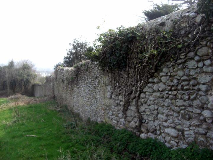
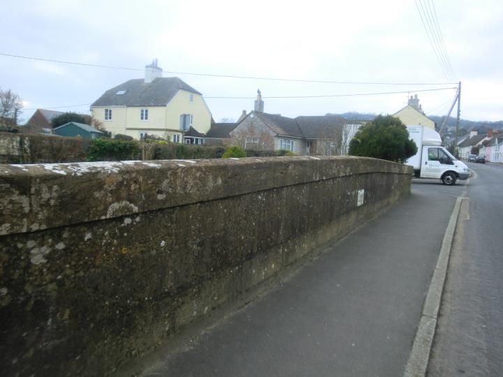
The thirteenth century wall along the rear of the buildings to the north of the Street is virtually intact and many of the long strip gardens can still be seen on both sides with a bank marking it to the south.
|
|
|
|
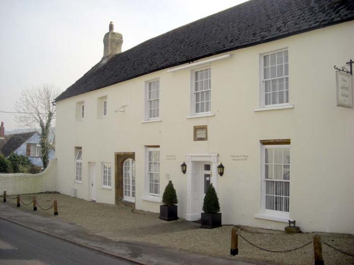
There was to be a revival in the fortunes of the village in the early 16th century under the last Abbot, Thomas Chard who was the Lord from 1521 until the dissolution in 1539. The initials T.C. still grace a former doorway in the Abbots House, formerly the Queens Armes on the Street and provide a clue to the fine building this must once have been. He was also instrumental in rebuilding the Church and manor House. His major work was on Forde Abbey itself which is embellished with his initials on the additions he made whilst there. The Abbey would have been responsible for maintenance of The Street and there a number of references to it in the Cartulary. The lay Subsidy of 1525 reveals a population for the village of about 200 at that time, though it accounted for less that 10% of the total income of the Abbey. The deeds to The George, The Fountain (Charmouth House) and The Rose and Crown go back to the times of the Monks and must have at one time served as hostelries for travellers on the road from Dorchester to Exeter.
|
|
|
|
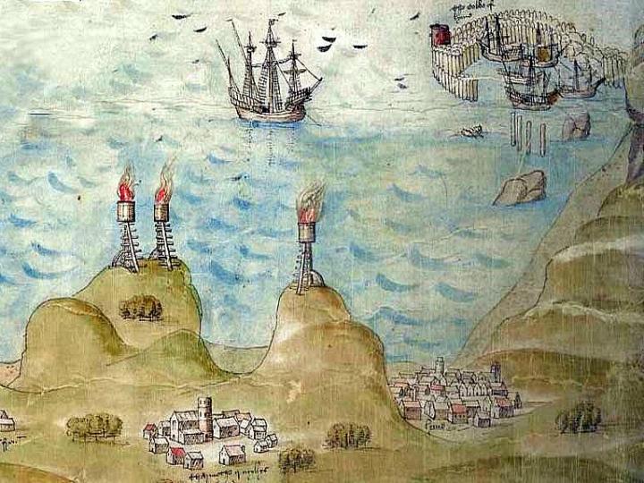
In 1539 a map was commissioned to show the defences along the Southern coast. Beacons depicted here on the high hills were to summon the local populace to the invasion point and new blockhouses were to house cannon. King Henry VIII`s plan was to stop any invasion fleet before it was able to land an army. The key aim was to identify landing points, anticipating how an invasion commander might think. Such beaches were highlighted by exaggerating their size, and sites for possible forts were added in appropriate locations. Charmouth is depicted with its Church surrounded by a group of houses surrounding it on the left and Lyme Regis on the right. The quay with a group of boats alongside it in the distance is the Cobb, which was separate from the mainland at that time.
Unfortunately the fortunes of the village were to change in the same year when the village was given back to the Crown. Sir William Petre who was later to become the Lord supervised the deed of surrender of the Forde Abbey Estates.
|
|
|
|
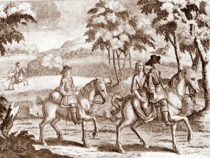
An important episode in the history of Charmouth was the brief visit of King Charles II. Captain William Ellesden, who owned much of Charmouth, assisted in the escape of King Charles II to France after the battle of Worcester. In September 1651 Charles stayed overnight at a relations house in Monkton Wylde, which still stands today before going on to Charmouth where a boat would be waiting to take him to France and safety. Unfortunately the scheme backfired when the boat mans wife found out and the future king was to spend only one night at what is now the Abbots House in the Street. This event was to put Charmouth on the map forever more.
|
|
|
|
He was to spend a night at what is today the Abbott's House shown here in earlier times with its cobbled road outside.
|
17 |
|
|
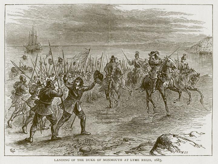
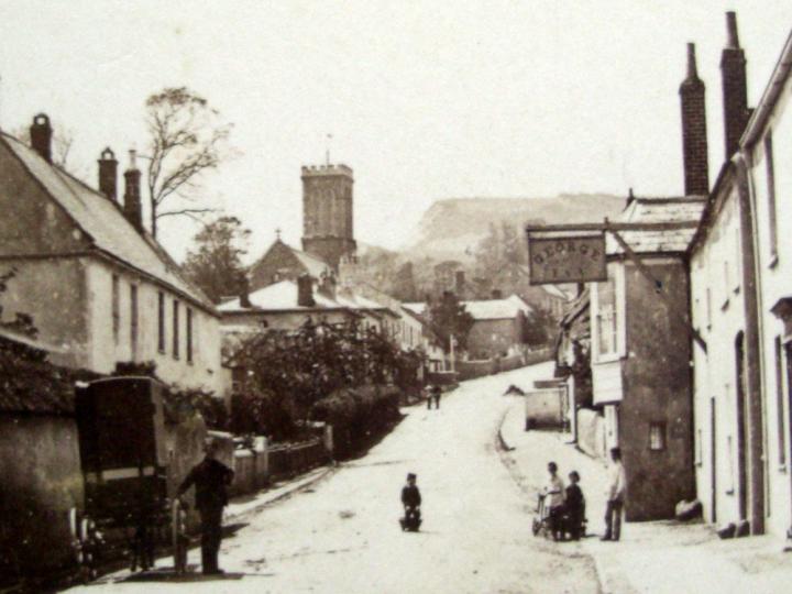
The next historic event Charmouth was involved with was the Monmouth Rebellion of 1685 which began on June 11 th when the Duke landed at Lyme Regis. A Party of four hundred foot and forty horse left Lyme Regis on the Saturday for an attack on Bridport.But on the Sunday they were routed, and in the afternoon came back helter skelter to Lyme. They left and returned out of the town by the still-existing lane to Charmouth along the bottom of the cliffs. The Duke of Monmouth was defeated some weeks after landing at the Battle of Sedgemoor, fleeing from the battlefield, only to be captured and executed on 15 July on Tower Hill.
|
18 |
|
|
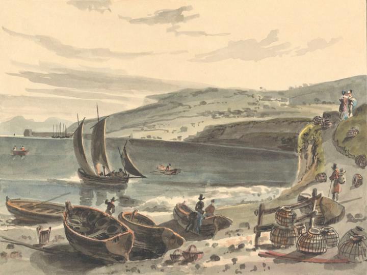
In the past the principle way out of Lyme Regis was by Coombe Street to Colway Lane at Horn Bridge. The only other was by a lane along the bottom of the cliffs to Charmouth which has long since disappeared into the sea. All goods that came in and out of the town on the landward side were carried in baskets(dorsers) on the back of pack-horses. This is the original water colour by William Daniel dated 1814 that shows the lane that went along the cliffs from Lyme Regis to Charmouth.
|
19 |
|
|
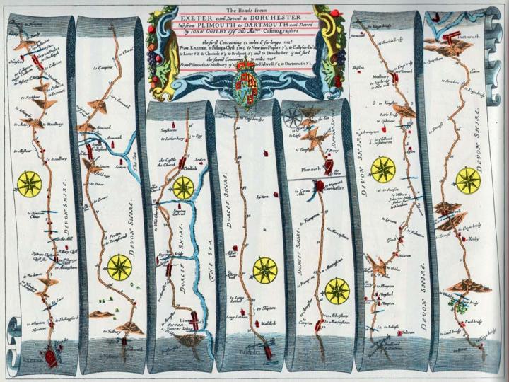
John Ogilby`s Map of Dorset dated 1675 showing the road system as it existed at that time. He produced a completely new concept in maps showing roads in strip form (from departure to destination) in a continuous ribbon format. Points of reference along the route were shown together with mileage and landmarks.
The road from Exeter to Dorchester, as Ogilby calls it, entered the county at Lyme Regis and ran to Charmouth (called by him "Shaderson", which is presumably a corruption of Catherston) near or along the coast, because the sea is described as lying near the road for several miles. Between Charmouth and Chideock he describes the road as crossing the Char by a bridge and then as leaving Stanton St Gabriel on the right, and passing "some houses on the road", and then his route climbed the flank of Stonebarrow Hill by Stonebarrow Lane, and followed the line of the Roman road along the crest to Morcombelake, and so to Chideock; and leaving Symondsbury on the left, arrived at Bridport.
|
20 |
|
|
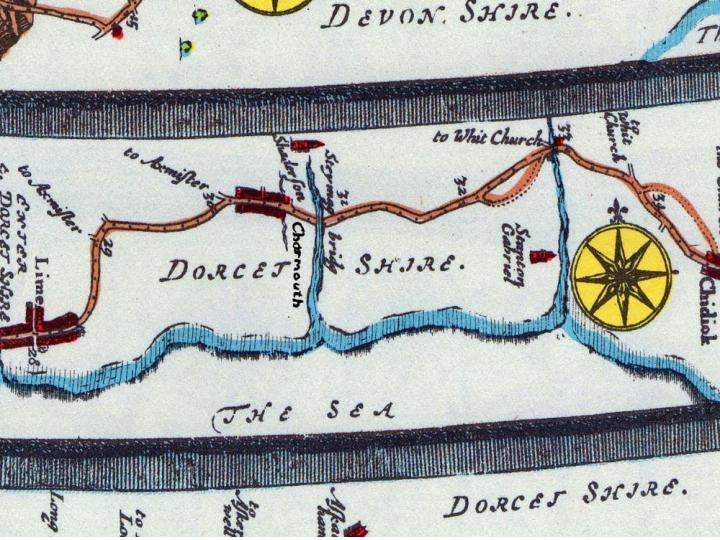
A close up of the map showing surprisingly accurate depiction of Charmouth with the road forking off on the west to Axminster and Lyme with a track to Wootton Fitzpaine (now Barrs Lane) in the middle of the Street. It is interesting to see Catherstone spelt Shaterstone.
|
21 |
|
|
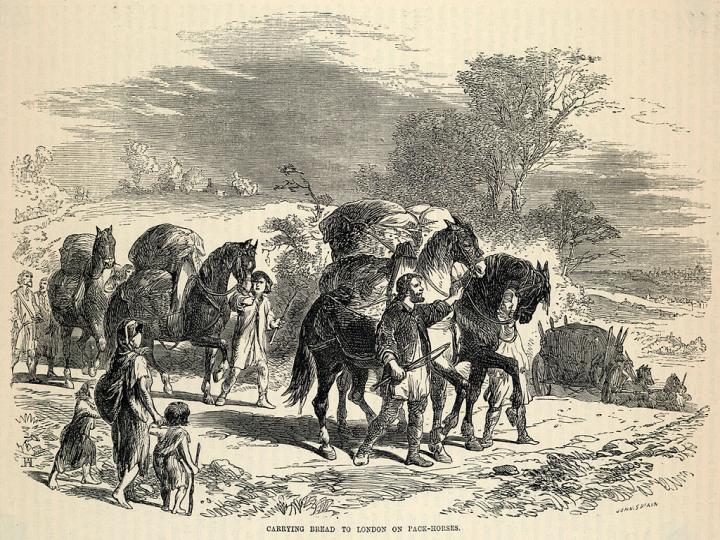
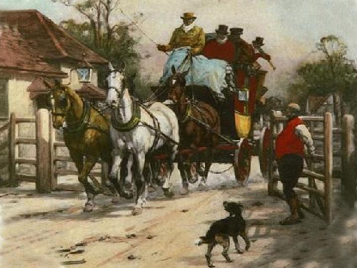
The main means of transport along the roads in the past were teams of packhorses which traversed the countryside, as shown in this contemporary engraving.
|
22 |
|
|
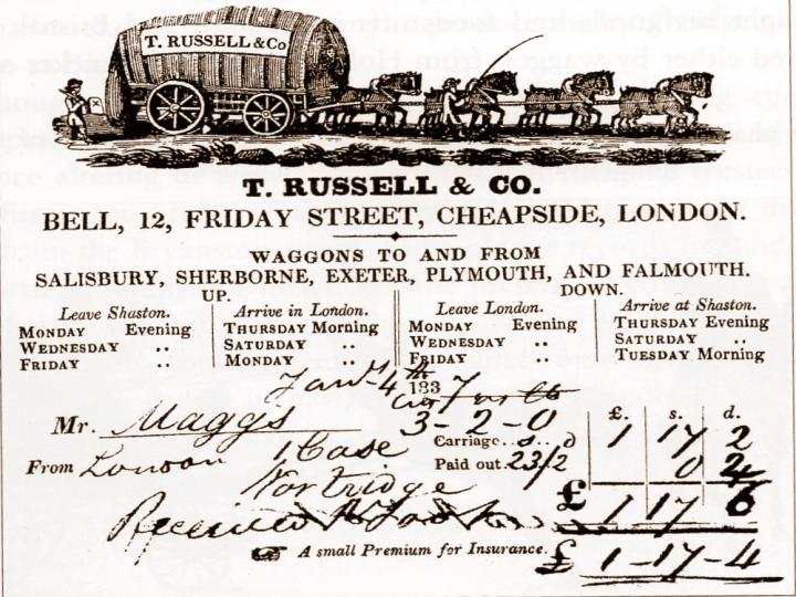
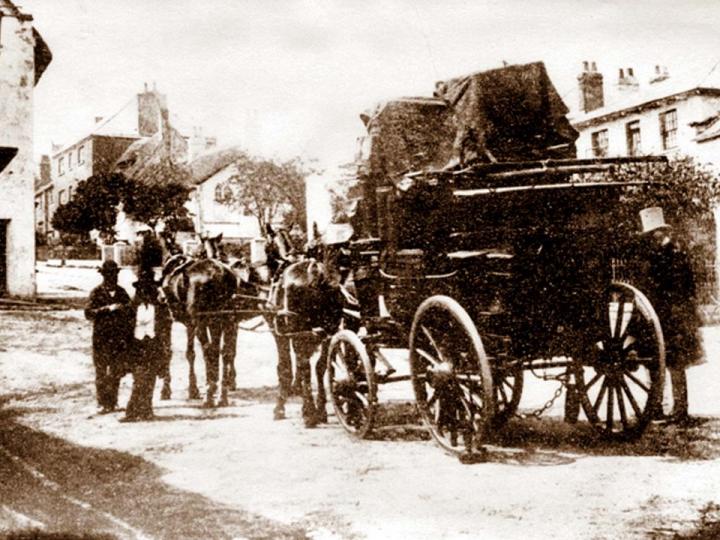
This letterhead shows a bill head for T.Russell whose wagons must have travelled along The Street between Salisbury and Exeter.
An important innovation in 1737, by a carrier on a Frome to London service, was the running of waggons continuously, day and night, with horses and waggoner's changed regularly - this faster service became known as flying waggons . The road speed of the service was no faster, but the time for Exeter to London was reduced, by Russell's, from seven days to 4 ½ days.
|
23 |
|
|
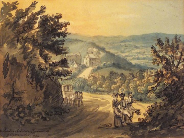
This interesting watercolour gives an idea of how the road entering Charmouth looked at the end of the 18 th century . The buildings in the background are of Penn Inn, where the farm is today.
|
24 |
|
|
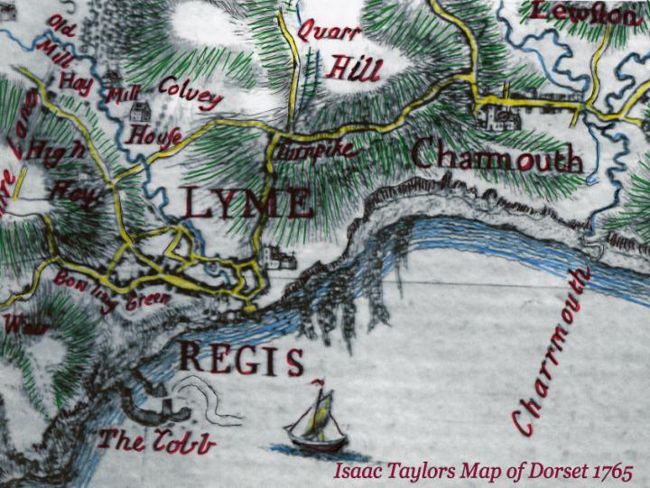
Isaac Taylor published in 1765 the first large scale map of Dorset of which this is a section. It shows the Great Western Road which travelled through Charmouth from 1757 and is marked as Turnpike. The creation of a well maintained road system was one of the great achievements of the 18 th century. They were created by a body of local trustees who levied tolls on the users of the stretch of road, generally around 20 miles in length. Using money secured against the toll income, a trust arranged to improve and maintain the road. The roads formed a network across Dorset. Though Charmouth had a number of turnpiked roads, the local roads were still the responsibility of the parish, repaired by local taxation. In the Dorset Record Office a Highways tax list for the village dated 1780 can still be seen. There was a steep decline in long distance road travel due to the arrival of the railways, though Charmouth gained by running a regular service from Bridport Station on to Lyme Regis. The Turnpike Trusts were eventually wound up in the 1870`s
|
25 |
|
|
In 1757, there is a description of the existing road as that High Road leading from the Almshouse at west end of Charmouth to and thru Lyme Regis which are in a ruinous condition, narrow in many places and very steep and uneven and by reason of the waters in the winter season unpassable at divers places and very dangerous to travellers cannot be repaired, widened by present methods As a result, the following year Charmouth had the first of its turnpike roads built. It was known as the Great Western Road and continued on as far as Aylesbeare, within a few miles of Exeter . It started from the top of the Street where there would have been a toll gate which were generally stout and substantial with keeper as depicted here. A turnpike was a gate set across a new or improved road which was only opened when a toll had been paid to the turnpike-keeper. During the day they may have been left open, or at least ajar, on a busy road but at night were closed and the pikeman would need rousing to take the toll (or, heralded by a coach horn, let the mail coach through free of toll). This individual lived in a tollhouse, which often had windows facing in both directions so that the keeper could see the traffic approaching from either side.
|
26 |
|
|
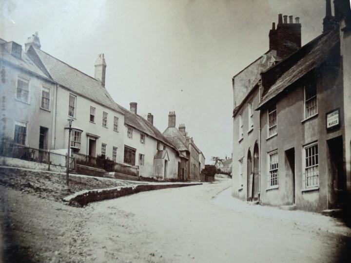
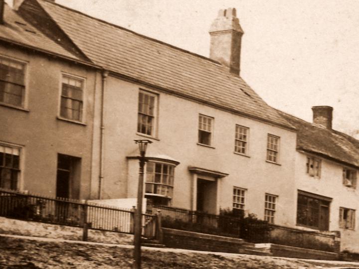
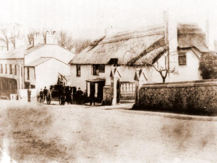
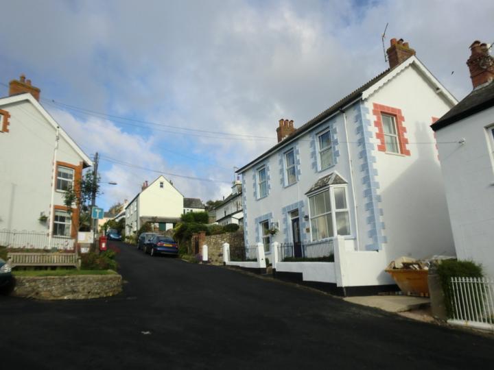
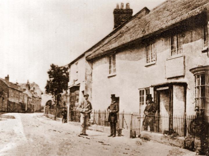
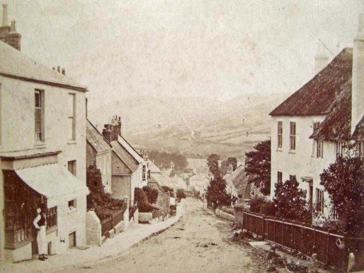
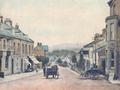
This photograph shows the top end of the Street in 1870 with many of the buildings unrecognisable when compared with today. This is especially the case with Claremont which was refronted by the Pryers at the end of the 19 th century. Here it is shown with a small bow fronted window projecting out into the street to the left of its doorway.
|
27 |
|
|
This is a close-up of the same building showing which must have originally been used by the Toll Keeper who could see any passing coaches from the window. In 1758 when it was built, it was owned by Benjamin Bradford who purchased the farm with 21 acres behind it, later known as Foxley Farm.
|
28 |
|
|
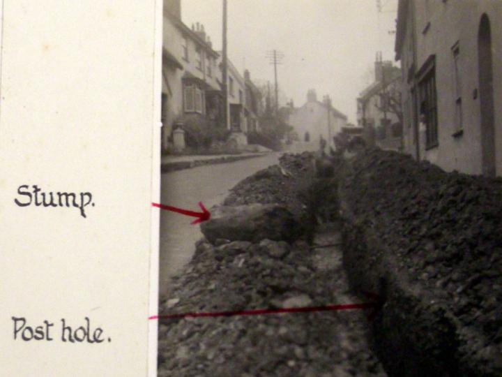
Evidence of the gate which would have gone across the street was found by workman laying drains in the form of the stump and the post hole of part of it. In 1939 the other Stump was found on the opposite side. The original Gate was demolished shortly after 1874.
|
29 |
|
|
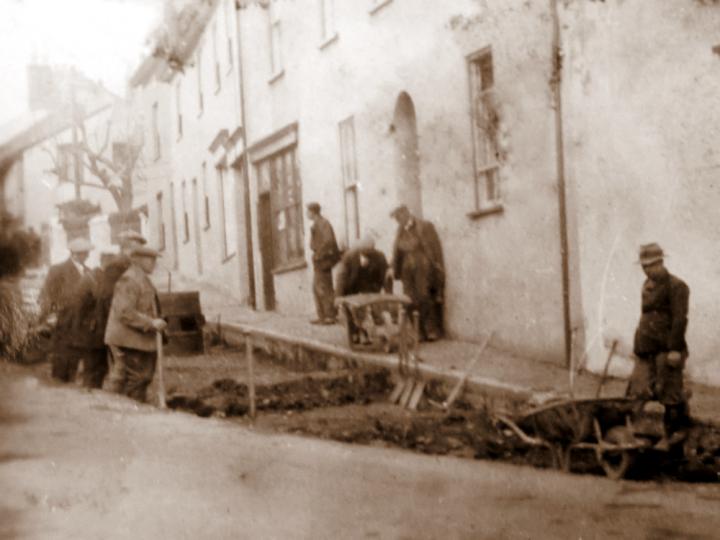
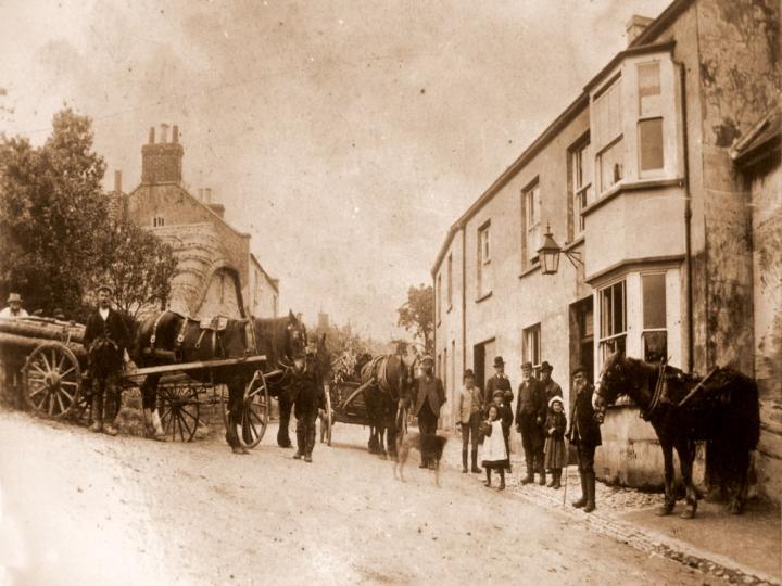
Here are the workmen busy at the time. The buildings in the background are Waterloo House( now the fossil shop) and Granville House which at that time was a shoemakers owned by the Hutchins.
|
30 |
|
|
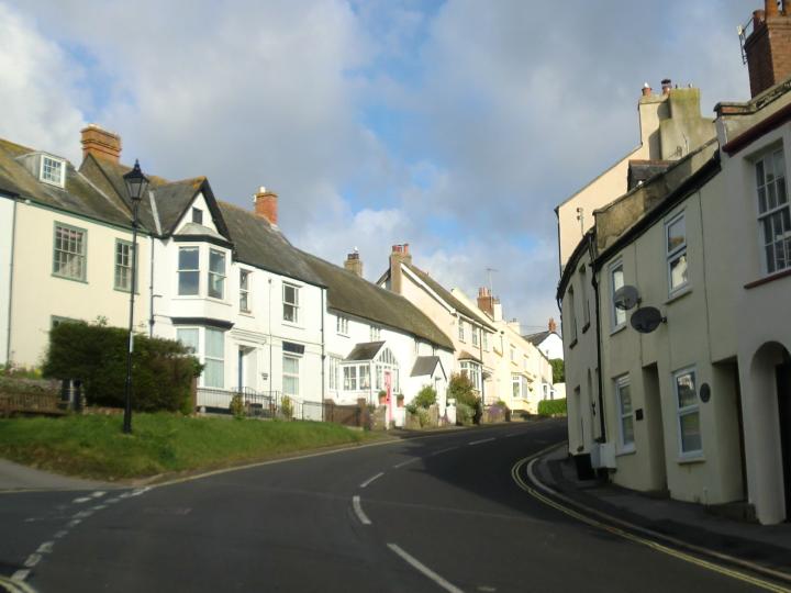
As we see it today, with Claremont showing the gabled Victorian front which was a later addition, masking the attractive Georgian exterior.
|
31 |
|
|
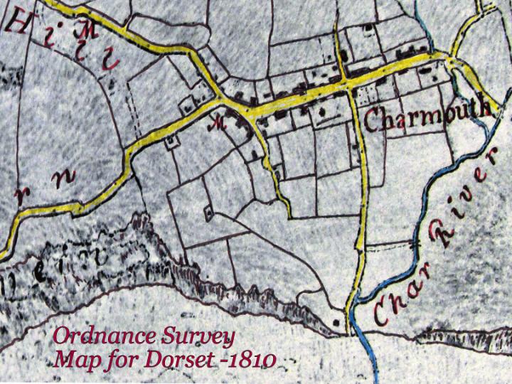
This map is taken from the Survey taken by Colonel Mudge of the area in 1810 which can be seen in the British Library. It shows the Turnpike road towards Axminster and the route to Lyme known as the Roman Road. The road to the sea was known as Sea Lane then and Higher Sea Lane finished at Double Common. Barr's Lane is shown clearly and would have been for centuries a major road linking Wootton Fitzpaine with Charmouth and the sea.
|
32 |
|
|
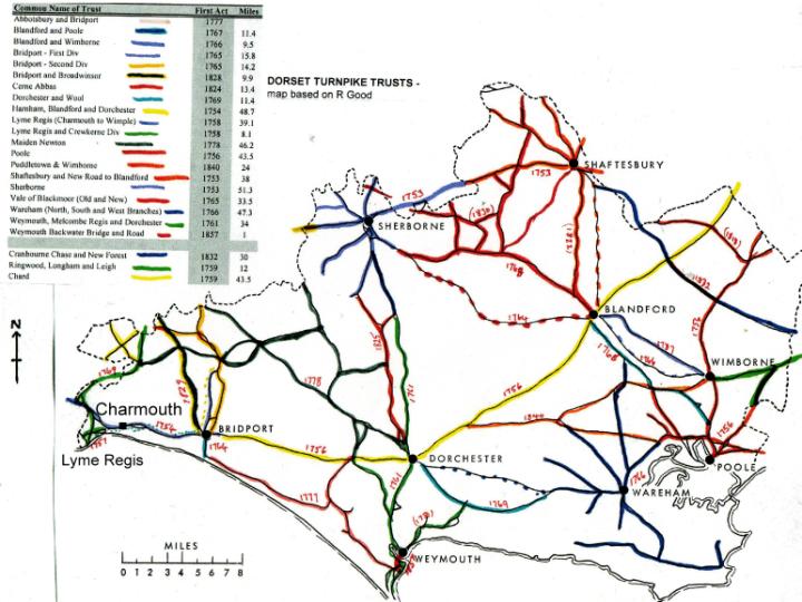
This map of Dorset taken from Ronald Goods "The Old Roads of Dorset published in 1966 gives an idea of the many Turnpike roads covering the county from the mid 18 th century.
|
33 |
|
|
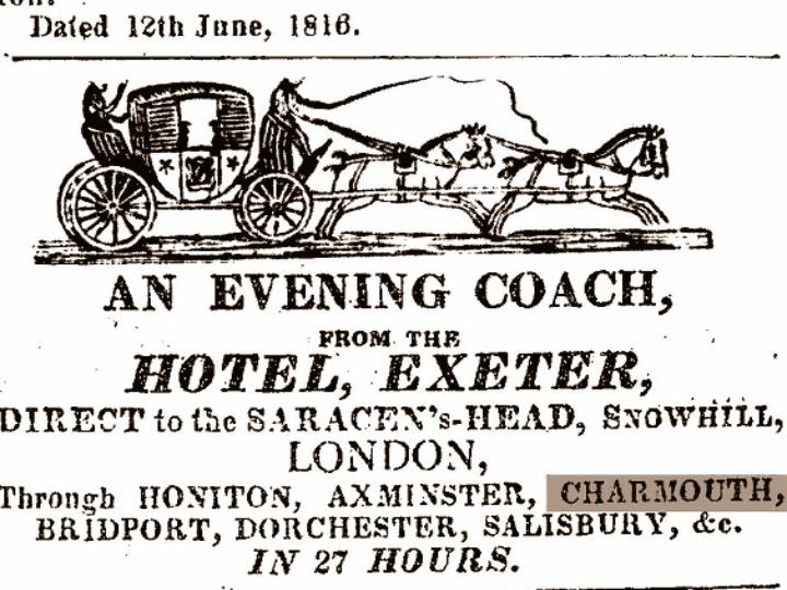
An early newspaper advert publishing the Coach from Exeter to London which would have passed through Charmouth.
The local newspaper records on the 7 th April 1739 -
"Our townsmen beheld by only going to Charmouth, the wonder of the day, better known as " The Exeter Flying Stage Coach" which reached Dorchester from London in two days and reached Exeter in three days. The lofty Stonebarrow Hill had to be ascended from Morcombelake and the descent - a perilous one - to be made by the main road, better called narrow lane, beyond the eastern brook by Charmouth, since abandoned for one further inland, and recently for one still further inland, by which the hill from Morcombelake is altogether avoided."
|
34 |
|
|
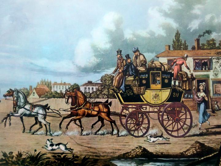
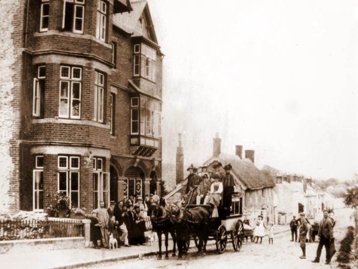
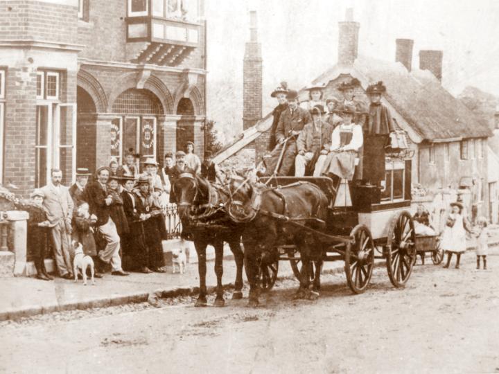
The Great Western Turnpike of 1758 combined with the other newly completed roads allowed the Coaching Inns in the village to enter a golden age. In 1839 a letter in the Chapel Book of Records says that seven or eight coaches passed daily through the village. The largest was the Coach and Horses next to the Church. But in 1754 it was called the Three Crowns and for the next 40 years it was owned by Mrs Hannah Newberry. She was to live on until 1793. We are fortunate that the Alehouse records for Dorset in 1761 show that as well as Hannah Newberry, there was John Goring running the Fountain, John Diment the George and Sarah Hardy at the Ship, which was probably what was to become the Star Inn.
She leaves her property to her grandson William Edwards who let's it to James Bradbeer who is also described as the village Postmaster in his will of 1821. In 1826 the name is changed to Mail Coach Inn as a result no doubt of this important trade. In 1760 a Mail Coach is recorded as killing a man in the village parish records and in 1805 another Coach overturned killing Ann Pitt. |
35 |
|
|
This attractive print shows a Mail Coach passing though a village with a coachman throwing down a bag of post to the young girl standing outside the Post Office.
|
36 |
|
|
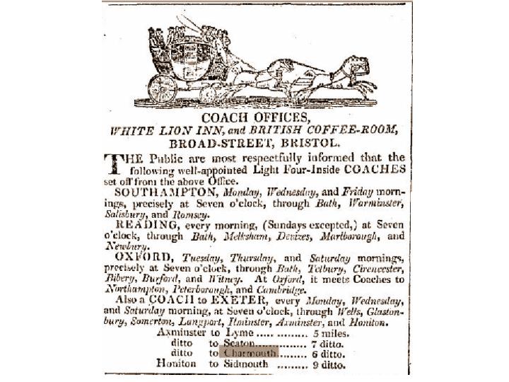
This is an early advert for coaches leaving the White Lion Inn in Bristol showing Charmouth as one of the stops on the route to Exeter.
|
37 |
|
|
This print shows how the travellers would have to walk up the hills when they were too steep to reduce the load. A famous occurrence of this was when King George III came to the village and is described in the local newspaper on the 20 th August 1789 as follows:
"Between Bridport and Chard are two very large steep hills, Chideock and Charmouth. It was impossible for his majesty's horses could here proceed in the swift manner in which he usually travels. The King, Lord Courton, Colonel Goldswothy, &c. dismounted, and walked up the hill. The King said he had never travelled such a stage in his life. During all this part of the road the multitude walked with him, and at times conversed familiarly with such as were near him.
The people of the village of Charmouth had prepared a lofty triumphal Arch of oak bought, with a crown of Laurel and wreaths of flowers".
|
38 |
|
|
This early drawing of the village shows the new turnpike road travelling through the village past the toll house. A Cutting which can be seen in the distance which was made in constructing the Lyme - Charmouth road in 1824 was known as the Devils Bellows from the force with which the wind rushed through and was known to blow over a horse and trap
|
39 |
|
|
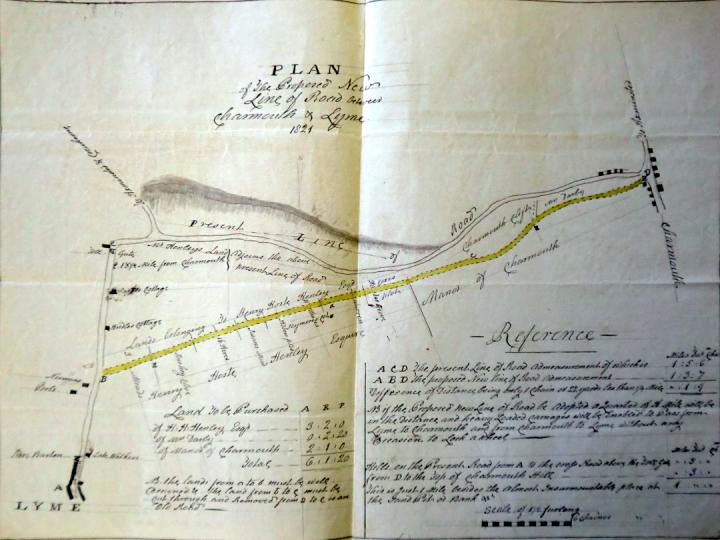
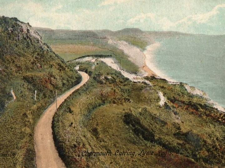
The Lyme Regis and Crewkerne Trust established by an act of 1757-8 originally comprised the road from the almshouses (St. Gabriels) at Charmouth through Lyme Regis as far as Uplyme. There were no roads to Lyme so coaches would leave from Charmouth. This originally followed by the name of the Roman Road, which continues into Colway over Timber Hill, but for some reason or other, perhaps steepness and exposure, the Charmouth end of this was later abandoned.
But i n 1821 a scheme was proposed to cut a new road south of it across the upper part of the undercliff of Black Ven through to Lyme Regis which would not be so steep as the existing one. The original map, now in the Devon Record Office shows the route it was to take when completed in 1825. The earlier route became known as Old Lyme Hill and the new one- Old Lyme Road.
|
40 |
|
|
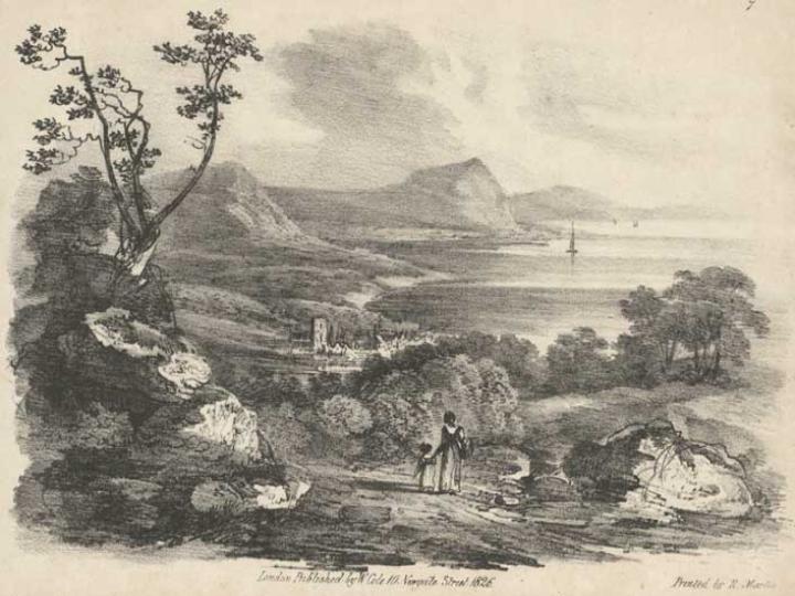
This is an artists impression of how the New Road looked in 1830, with the Church spire in the distance.
|
41 |
|
|
This photograph shows the junction of Old Lyme Hill and Old Lyme Road in an area known as the Wedge about 1900. The large square house in the centre is the Mount which was built by Mr Niblet in 1897. The fields on both sides of the road belonged to Foxley Farm.
|
42 |
|
|
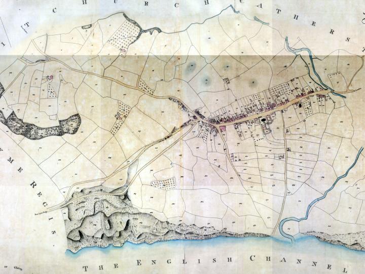
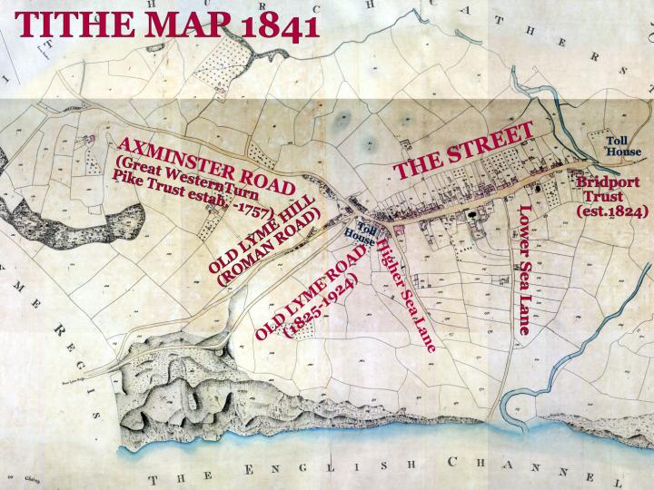
This is the earliest accurate large scale map of Charmouth known as the 1841 Tithe Map showing the new roads.
|
43 |
|
|
The same map with labels showing the various roads that existed at that time.
|
44 |
|
|
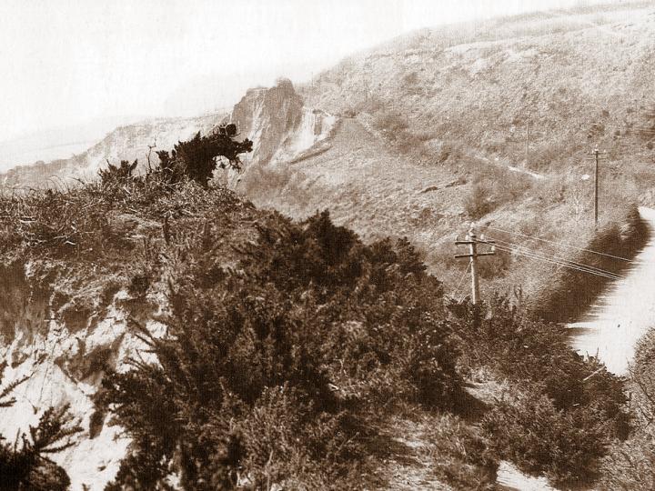
The road shown here led into Charmouth through the Devils Bellows. It was cut in 1825 as a link to Lyme Regis, as the old Roman and later Coaching road was steep and hazardous. Lyme road was opened in 1825. It sank 20 feet in 1828. But even in 1912 the papers referred to the terrible state of it. The cliff below Charmouth Cutting had been slipping for some years and was halted for a time by the surface of the road. When this gave way the fields above the Cutting gradually disappeared Finally on 26th May 1924,it was closed to all traffic, after a landslip and the Roman Road followed in about 1957.
|
45 |
|
|
A more dramatic view showing how precarious it was in the landscape.
|
46 |
|
|
Another view in 1890 showing the Old Lyme Road, now sadly gone.
|
47 |
|
|
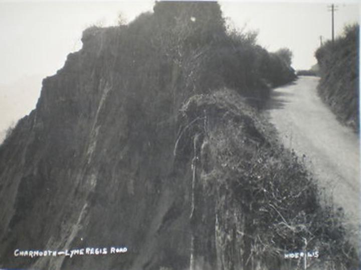
This dramatic photographic postcard was published in a series shortly after the great landslip by Claude Hider of Bridport. A bad slip of the cliff near the Western cutting took place at the end of 1922. A worse slip followed at the same point in May, 1924, so that the edge of the cliff was only a few feet from the side of the road.
|
48 |
|
|
Another Claude Hider photograph showing the landslip alongside the road.
|
49 |
|
|
A view looking down Old Lyme Hill, with Digory Cottage on the right.
|
50 |
|
|
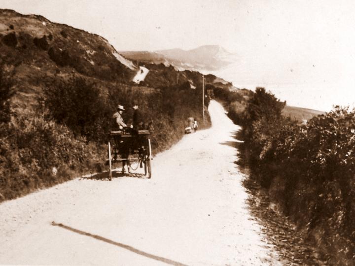
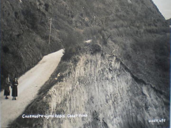
A view of the junction in Charmouth of Old Lyme Hill and Old Lyme Road. In August, 1916, a notice-board was put at either end to warn people that they used the road at their own risk. Reiterated and more emphatic warnings were posted up in 1921.
|
51 |
|
|
The view today.
|
52 |
|
|
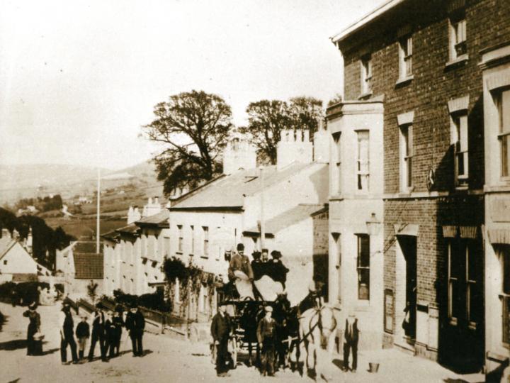
This photograph from 1860 shows the New Commercial Inn which stood at the top of the Street and must have gained its business from the increased traffic coming to the village on the completion of the Great Western Turnpike Road of 1758. There was an extensive fire in 1886 and it was rebuilt.
|
53 |
|
|
This photograph shows the later building with a number of wagons outside marking the junction of the road to Lyme Regis and that for Axminster. The pretty thatched cottage in the distance was later to be demolished to make way for a car park for the New Inn.
|
54 |
|
|
The New Inn as we see it today converted into three dwelling houses.
|
55 |
|
 |
One of the earliest photographs of Charmouth showing a splendid shop front opposite Charmouth House, which at that time had iron railings and was being run as an Inn by George Holly.
|
56 |
|
|
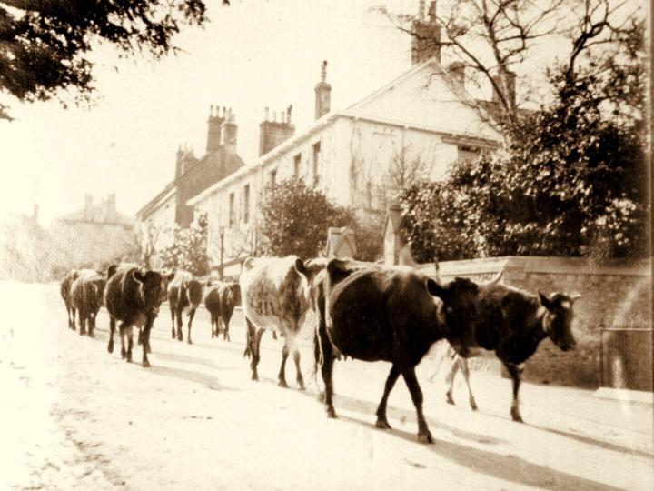
How times have changed with Cows passing The Court, which was a regular occurrence as they went on their way to being milked in the Dairy at Backlands Farm situated opposite the church.
|
57 |
|
|
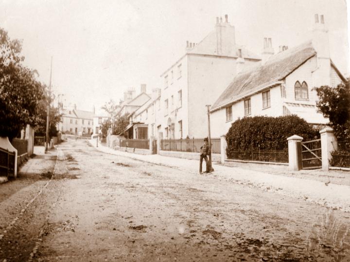
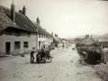
Many of the early photographs reveal the unmade state of the roads, with their cobbled pathways. The thatched building on the right now called Alberry House was then known as The Cottage. Adjoining it was Luttrell House with its fine Georgian front which was later considerable altered.
|
58 |
|
|
The young men stand proudly by their Pony and Trap outside the Royal Oak on the right. Notice the mass of pebbles making up the pathway and gutter.
|
59 |
|
|
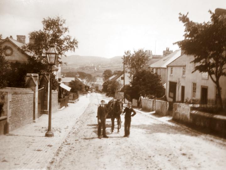
A smashing shot of 2 young girls rushing to get on the Brake which would have left the Coach and Horses on its way to the Railway Station at Axminster. On the right is the doorway to Luttrell House.
|
60 |
|
|
This photograph was taken outside the Old Manor House at the turn of the 19 th century and shows the Axminster Wagonette , which must have been the equivalent of the 31 bus which stops outside today.
|
61 |
|
|
An early photo from about 1880, when the old thatched Coach and Horses was still standing.In earlier times it had been known as the 3 Crowns and then the Mail Coach Inn
|
62 |
|
|
This is thought to be the earlist photograph we have of Charmouth. It shows the last day of the Coronet coach which ran between Bridport and Exeter from February 1858 till the summer of 1860 when the opening of the L.S.W Railway to Exeter brought the service to an end.It left the Bull Hotel Bridport at 11.30 a.m. Arriving at Pratts Hotel in Exeter at 5pm. In the reverse direction departure from Exeter was at 10.am Bridport beng reached at 3p.m.
The fares between Bridport and Exeter were : inside 12/- Outside 8/- the photograph is of interest as it shows portion of Lydia Watts cottage which was pulled down in 1861 when he church was enlarged. On the opposite side of the road can be seen Hillside, Alberry House and Lutrell House.
|
63 |
|
|
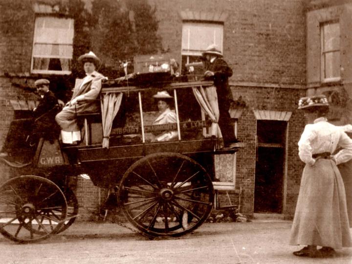
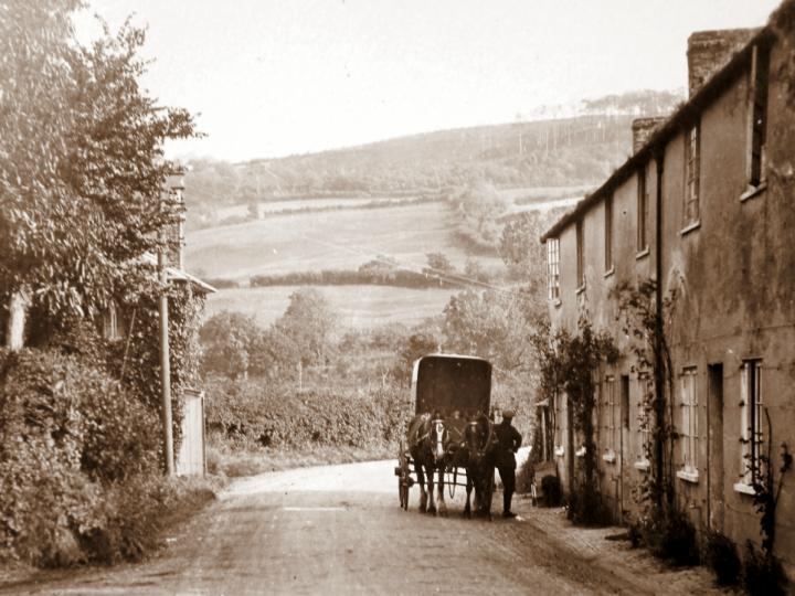
in 1858 a Lyme-Bridport horse omnibus started, leaving Lyme in the morning and returning in the evening. The Bus had room for 6 passengers outside and 6 inside and continued till August 1922, when it had to give way to the all-conquering motor .The driver shown here with a full coach was Mr W. J. Hounsell. All through the coaching era, travellers to Lyme changed either at Charmouth or at Axminster on the main route according as they came from North or South.
|
64 |
|
|
A close up of Holly's Omnibus which took passengers from the Coach and Horses , whose entrance can be seen in the background, on to Bridport. Notice the G.W.R. standing for Great Western Railway on the side of the carriage for which he was an agent.
|
65 |
|
|
The Coach and Horses now converted as so many other large buildings in the village to Apartments.
|
66 |
|
 |
This must be one of the best photographs taken of the village. It has been hand coloured to make it even more exciting. The carriage outside the Coach and Horses appears regularly in photos of he period and must have been permanently parked there as an advert for the Hotel. The board leaning up against the window is publicising the coach rides in the area.
|
67 |
|
 |
A magnificent image of days gone by, with a view that has changed radically over the years. Most of the buildings on the left were to be lost to fires. The hedge stretching to the Queens Armes in the distance was the boundary of Pear Close, owned by Pusey Pryer who ran his business from the workshops on the corner of Lower Sea Lane.
|
68 |
|
|
An almost unrecognisable comparison with the previous rustic view from the same spot.
|
69 |
|
|
Holly's omnibus is seen here dwarfed by the mass of Sunnyside (Devonedge), which at that time stood on its own.
|
70 |
|
|
Visitors are seen here leaving by the bus which is driven by Mr William Holly junior. Standing on the pavement seeing them off are James Harrison (2nd on left) Mr C. Fletcher, Miss Ada Hill, and the misses Hutchinson. Behind are Mrs Cole and Miss Dare. Mr Farrang, assistant baker is in the doorway. Mrs Taylor is behind the boy on the right.
|
71 |
|
|
This is an early view from about 1870 of the George Inn which had long been a coaching inn, with its distinctive projecting window where customers could look down on to the road to see when the coaches were coming.
|
72 |
|
|
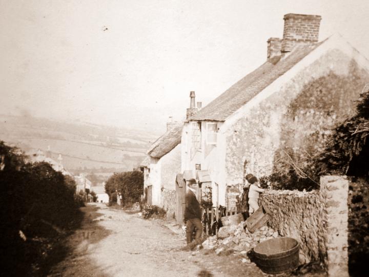
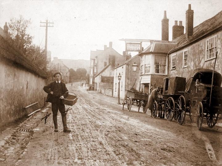
Frank Cole`s son with his empty basket after delivering loaves of bread. The wall behind him is interesting as it made of clay and straw and is known as a Cob Wall. The road seems to be covered with mud. A group of carriages wait outside the George Inn for customers. The shocking state of the road can be clearly seen.
|
73 |
|
|
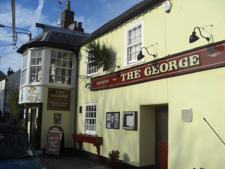
The George today
|
74 |
|
|
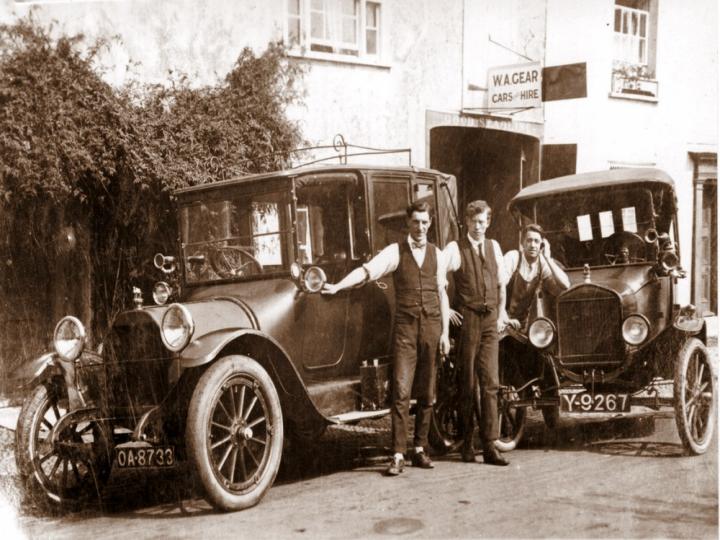
The former coach houses at the rear were adapted by Billy Gear in 1927 for the first of his garages. He is shown here proudly standing outside with his workmen
|
75 |
|
|
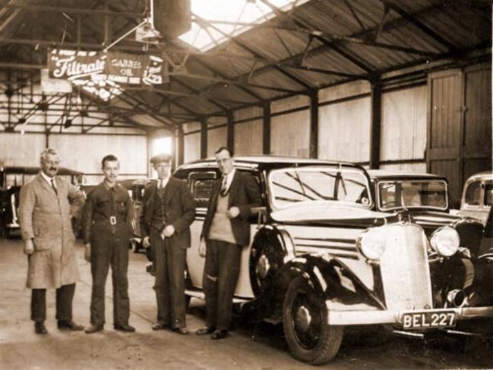
A later photograph provided by Jill Mathews showing her father in Billy Gear`s Garage after it moved to the centre of the village.
|
76 |
|
|
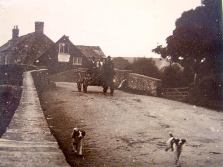
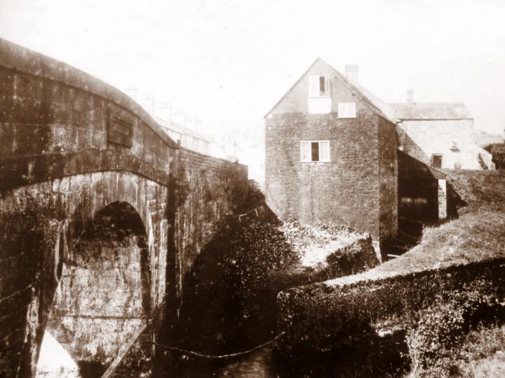
The photograph shows the Mill in the distance and a Farmer crossing the old bridge with his dogs ahead of him at the turn of the 19 th century.
|
77 |
|
|
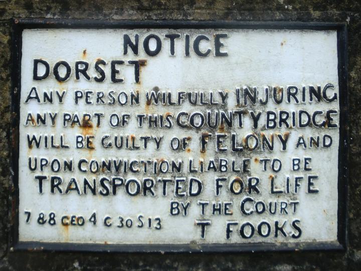
Charmouth Bridge was one of several bridges which contained the following warning:-" Dorset. Any person wilfully injuring.any part of this county bridge will be guilty of felony and upon conviction liable to be transported for life by the Court. T.Fooks. He was the Clerk of the Peace from 1826 to 1839. During the war in 1940 when a German invasion was threatened the word "Dorset" was cut out.
|
78 |
|
|
The present Mill bridge was built by J and W. Short in 1824 . It replaced an earlier one as Hutchings writes in his history "Order for the inhabitants of Whitechurch Hundred (which included Charmouth) to have liberty to build a bridge over the river at the east end of the parish,1662. Order set aside and the inhabitants of Charmouth to build said bridge.1671" It no doubt replaced an earlier one as there references to there being on in the Forde Abbey Cartulary. The photograph was taken by James Harrison about 1900 when the Mill was still working. The Mill Pond can still be seen on the right.
|
79 |
|
|
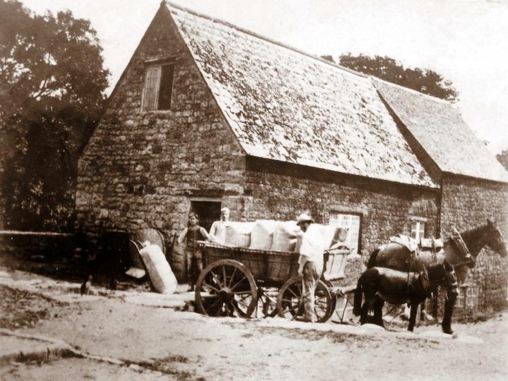
A close up of the Mill with sacks of flour being loaded on to the cart. The Miller at this time was John Toms. When he died it was bought by Colonel Bullen,but was not very successful due to competition and went into decline.
|
80 |
|
|
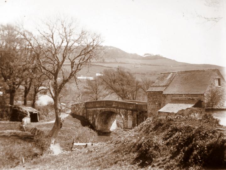
A view from the river bank of the mill The medieval mill was probably on the same site as the later mill which lay at the eastern end of the town on a small tributary of the Char.
|
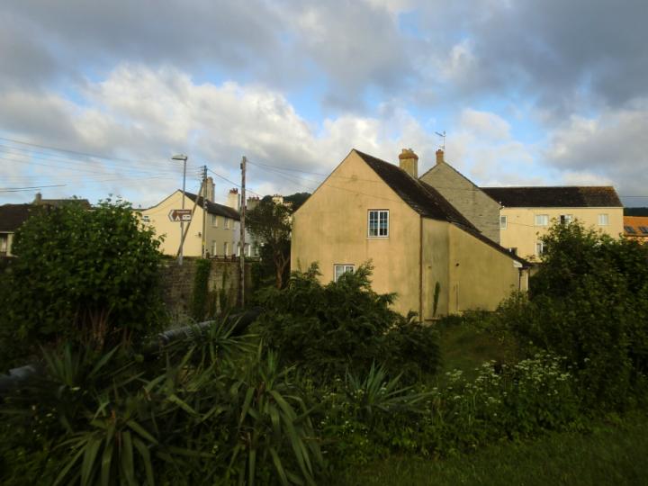
|
|
|
The view of the Mill and Bridge as we see it today from Manor Farm
|
82 |
|
|
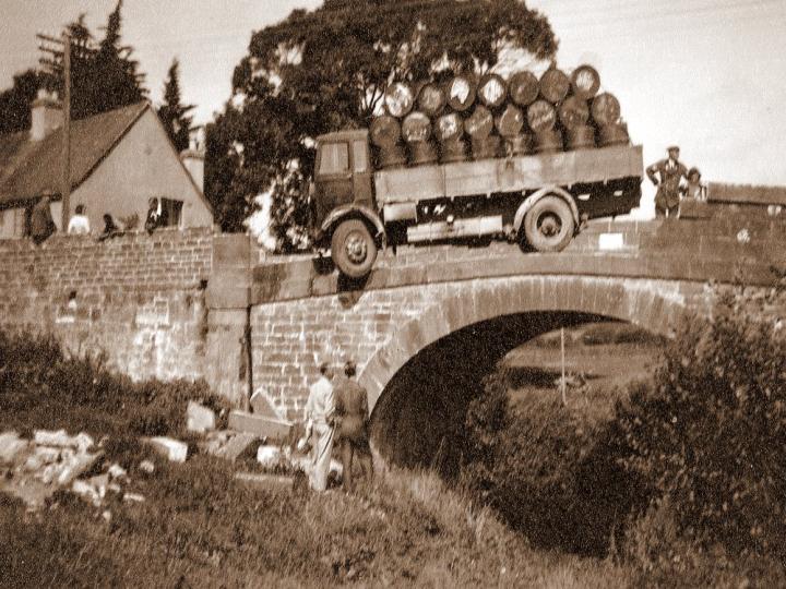
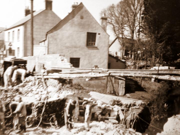
The bridge had a dangerous hump, was narrow and curved. In 1937 a lorry collided with the south parapet, which had to be replaced by an iron railing.
|
83 |
|
|
This photograph shows the bridge being rebuilt in 1957.
|
84 |
|
|
The Bridge today with the warning sign in the centre.
|
85 |
|
|
The Bridport Omnibus is seen here leaving the village over the bridge.
|
86 |
|
|
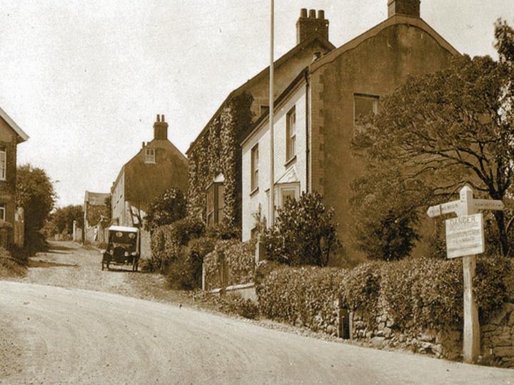
The building on the left is one of a number of toll houses that were built along the route of the Turn Pike road in 1826 linking the village with Bridport. The row of cottages were at one time rented to Customs Officers.
|
87 |
|
 |
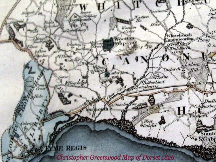
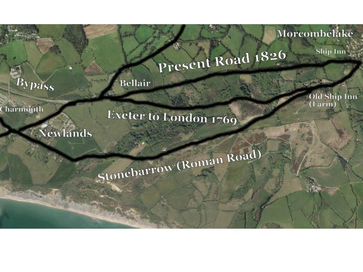
This Map dated 1836 by Greenwood details the roads around Charmouth. It is especially interesting as it shows the three routes to Morcombelake. The earliest is the old Roman Road marked Stonebarrow Hill. Then in 1769 it was cut to make the ascent of Chideock Hill more gradual by taking the road a little to the north-east moved and is shown in brown. Finally in 1827 another straighter road was construed marked in grey. At Morcombelake there was a well-known inn called the Ship on the old road, and this was moved to its present position a little further north, the old house becoming Ship Farm .
|
88 |
|
|
These are the same roads that still exist superimposed on an aerial photograph.
|
89 |
|
|
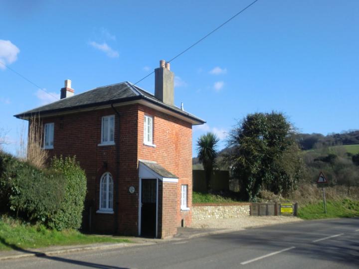
There was a gate at Charmouth where the Wootton Fitzpaine road branches off between the two rivers. Its Tollhouse dating back to 1826 can still be seen there today.
|
90 |
|
|
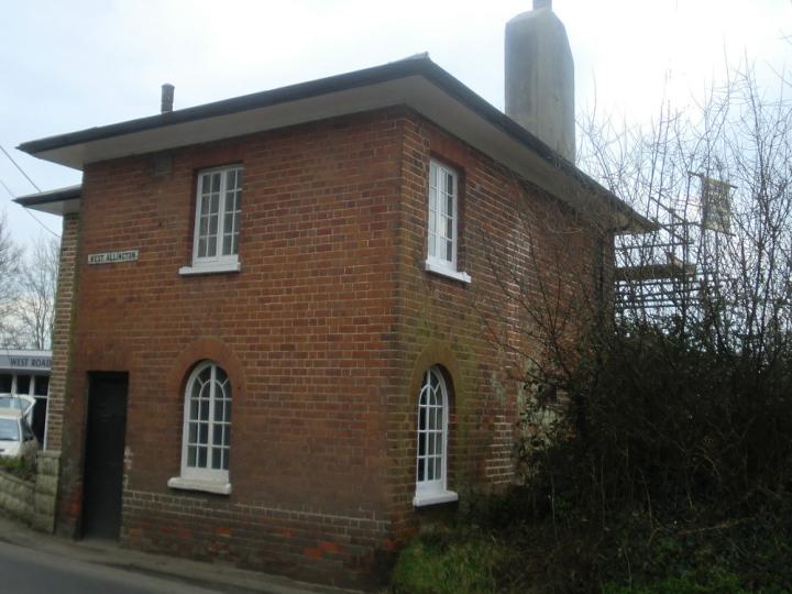
This is not the same photo but another identical redbrick Toll House at West Allington, Bridport
|
91 |
|
|
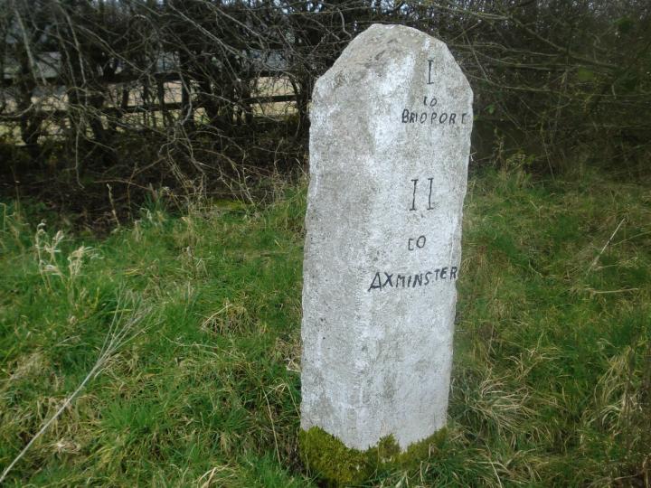
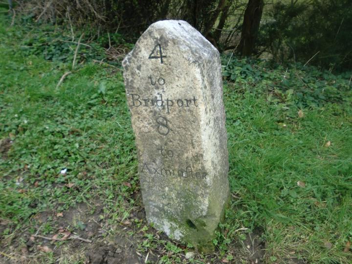
One of the many Milestones can be found along the old turnpike roads.
|
92 |
|
|
Another one!
|
93 |
|
|
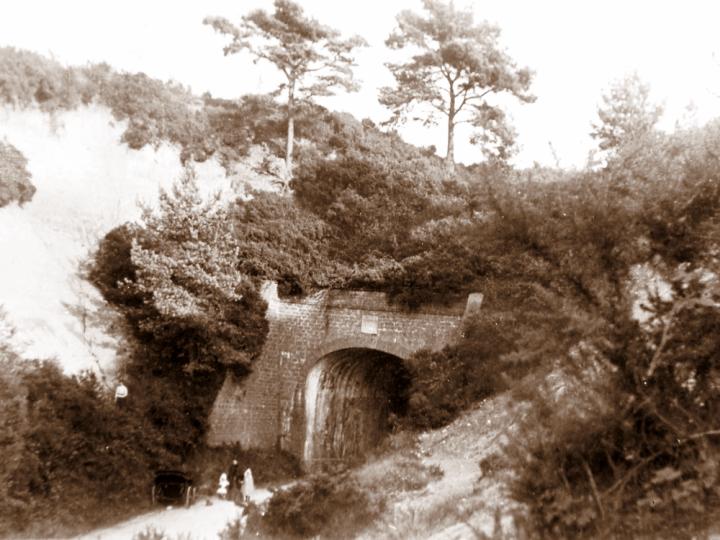
The Tunnel Road, which is in reality an extension of this new Morecombelake-Charmouth Road, was not opened till January, 1832, when two London-Exeter coaches passed one another in opposite directions amid much public rejoicing. The Tunnel was made so that coaches could avoid Fern Hill, it reduced the climb over Thistle Hill. This was the third English road tunnel and predates the other Dorset tunnel through Horn Hill, Beaminster by six months. It was 73 yards long, 20 ft wide and had an elliptical arch roof over 13ft high walls.
|
94 |
|
|
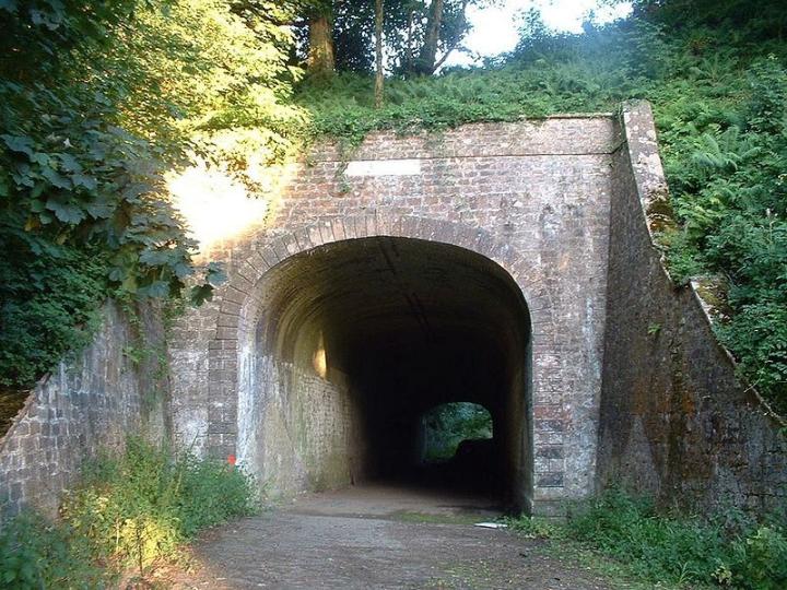
A photograph of the former road tunnel which became redundant when the Charmouth bypass was built in 1990.In 2004 Charmouth-based Clist Properties paid £ 50,000 for it before transforming into the Target Sports Centre, a world-class shooting facility with two ranges.
|
95 |
|
|
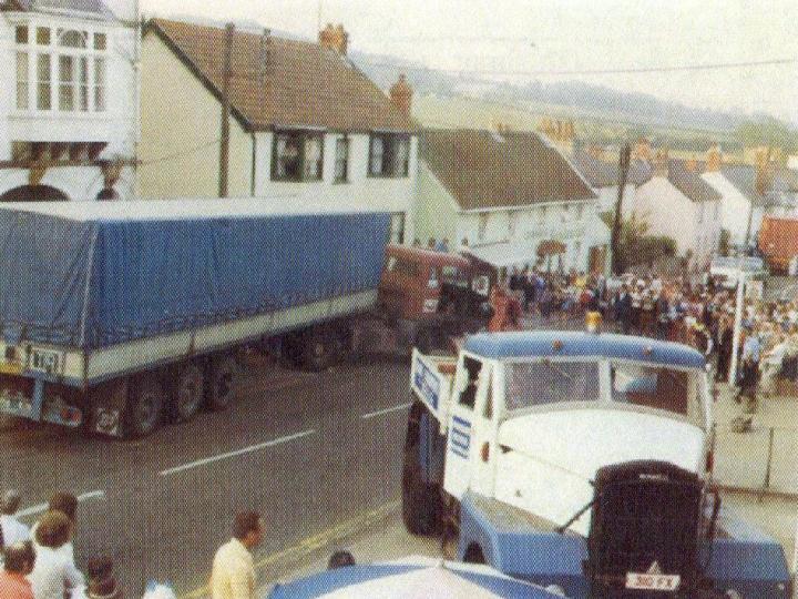
At one time the busy main A35 road went through Charmouth with its cars, Lorries and caravans. In the summer it became so congested that the police would block the entrance to Lower Sea Lane after 10.30a.m. as the car parks would be full by then. The steep hills would catch out lorries who would have to brake suddenly. There were a number of serious accidents, many of which were recorded by Mike Davis , the husband of Mary, who always had a camera loaded with film in the Pharmacy. This record in the form of an album was given to Linder Chalker, who was the Minister of Transport at that time and was instrumental in the village eventually getting a bypass which was opened in July 1990. The following photos are from an article Mary Davis wrote for the Village Echo for their Winter 2009 issue.
This photo shows one of the worse crashes. It was taken on a May Bank Holiday in 1978 when a large blue French Lorry careered down the road with brake failure crashing in to The Wander Inn (Red Buff). Ten minutes later another lorry at the top of the hills brakes failed as well due to the hot weather and came crashing down damaging 4 cars en route. It was a miracle that no one was injured.
|
96 |
|
|
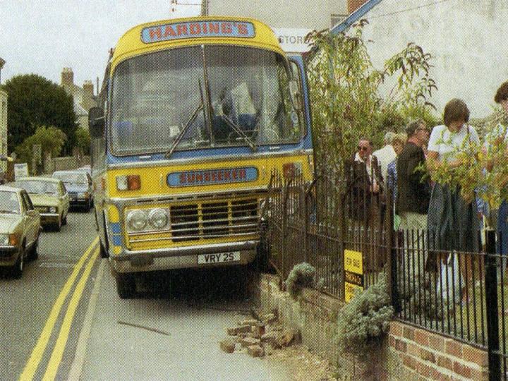
A Bus crashes into railings at Charmouth Lodge (The Limes) in August 1983.
|
97 |
|
|
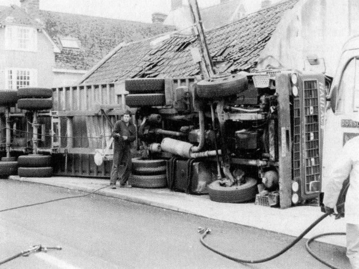
A Lorry demolishes Brackendale Cottage in the Street in January 1983
|
98 |
|
|
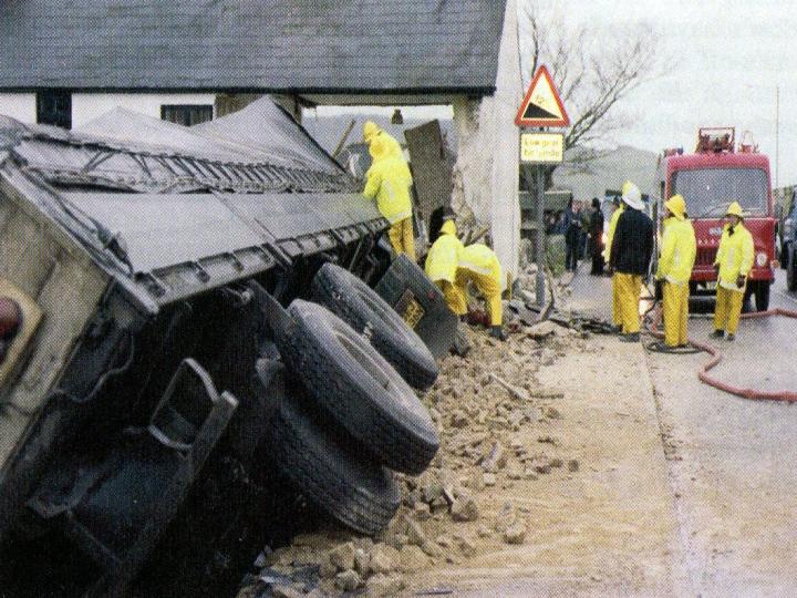
A Grain Lorry overturns at Braggs ( The Pharmacy) in January 1986. The side of the building fell in and was forced to close for a number of weeks and had to be rebuilt.
|
99 |
|
|
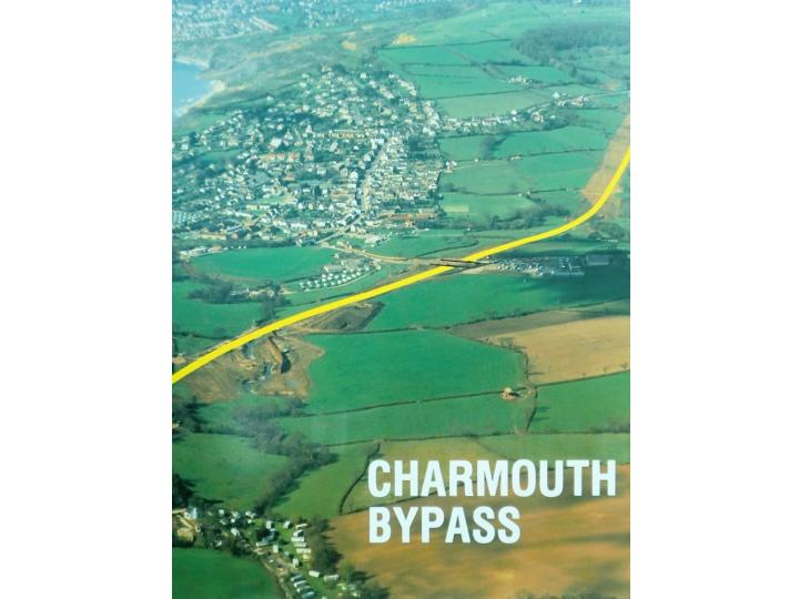
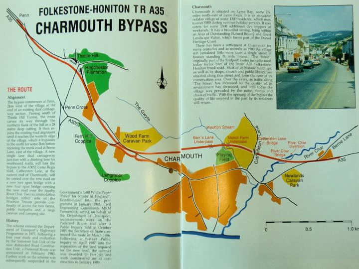
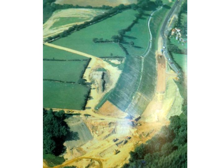
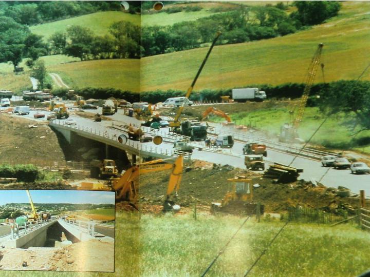
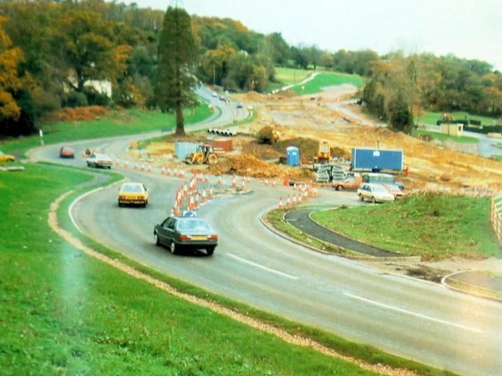
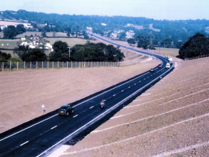
The Ministry of Transport published an attractive Brochure extolling the virtues of the new bypass completed in 1990.The following photographs show it whilst being built.
|
100 |
|
|
A Map of the route of the Bypass.
|
101 |
|
|
A view of the Bypass |
102 |
|
|
A view of the Bypass |
103 |
|
|
A view of the Bypass |
104 |
|
|
A view of the Bypass |
105 |
|