 |
|
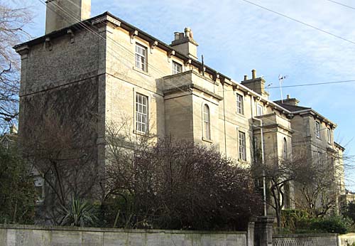
St.
Margarets Villas, Bradford on Avon
|
|
|
|
St
Margaret`s Villas
|
 |
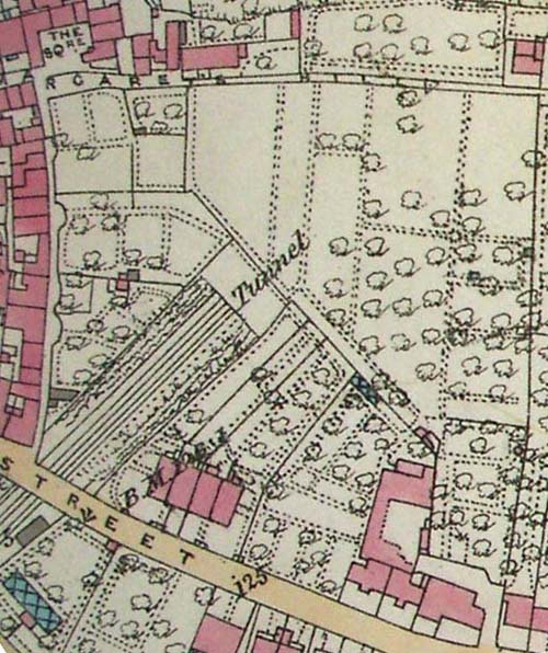
| Barton
Farmstead as depicted by Mrs Tackle in 1850.The "French Grass Ground"
was one of a number of fields that formed part of this farm originally belonging
to the Abbess of Shaftsbury. |
Introduction
When I purchased my house at St Margaret's Villas a year ago I really did
not expect to find a great deal on its history as it was built in 1906.
But I was fascinated by its rural setting way back from the main road with
a Railway Tunnel underneath it. There
is also the mystery of the long narrow path that forms part of the continuation
of St Margaret's Hill by the Scouts Hut along the ridge through to the Golf
Course.Even finding the Villas is very puzzling. I
was intrigued soon after moving in as to why the last and more imposing
house in the terrace was called French Grass House. It appears that the
name comes from that given to a large field that was originally bordered
by St Margaret's Place, Trowbridge Road, St Margaret's Hill and the lane
alongside Longs Yard.
I hope
in this article to solve something of the enigma that is St Margaret's Villas.
I have been fortunate
to locate some interesting documents, plans, photographs and maps, mainly
from the Wiltshire Record Office which may be of interest to others.
There are really four stories to tell in the development of the area which
are:
(a) The history of the field known as "French Grass Ground"
on which the Villas were built
(b) The impact of the Railway when it was tunnelled under the field.
(c) The story of the Long family of builders who left such an important
mark on the landscape of the town in the 19th Century.
(d) The construction of St. Margaret's Villas and the recent history
of the site. |
|
(a)
The history of the field known as "French Grass Ground"on which
the Villas were built.
|
|
"The French
Grass Ground" had for centuries formed part of Barton Farm until
its sale by Sir John Hobhouse in 1845. The earliest reference to this
name is 1722 and previously it may have formed part of the larger Avon
Field. The farmstead stood nearby and many of its buildings including
the Tithe Barn and Manor House still survive.
The ownership of the site can be traced back over 1000 years. In the Saxon
period it was in Royal ownership and from 1001 to the Dissolution it belonged
to the Abbey of Shaftesbury. It formed part of a sub manor known as the
"Lay Manor" centred on the nearby Barton Farm. Parts of the
account rolls has survived for five years during the reign of Joan Formage,
the earliest of 1367, the latest of 1392. It provides useful information
about Barton Farm, recording that 136 acres were used for wheat, and lists
other crops field by field. The Abbess`s Steward held a manorial court
at Bradford twice a year but was not based there. It seems that Barton
Farm was an administration centre, with rooms for the Steward, Reeve,
Hayward and Shepherd.There is also a mention of the Prebendal ( Rectory)
Manor which had been set up separate from the Manor of Bradford. It was
after the "Black Death"during the 14th Century that sub manors
were created with a number of families benefiting under this system including
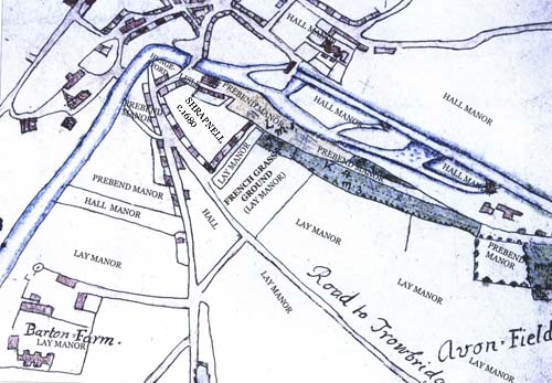
the Rogers and Halls who were to build fine houses in the town. A map
below shows how the area south of the river was subdivided into different
manors many of which survived into the 19th century.
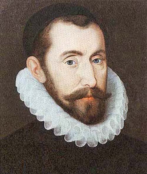
The Abbey was surrendered in 1539 to King Henry VIII and then later the
Manor of Bradford was leased to the Earls of Pembroke. In 1576 Elizabeth
I granted it to her notorious spymaster, Sir Francis Walsingham. He included
it in his wedding dowry for the marriage of his daughter Frances to the
famous poet, Sir Philip Sydney. She went on to marry Elizabeth's favourite
- the Earl of Essex and finaly Ricard Bourke, Earl of Clanricard in 1603.
When he died in 1635 the Estate passed into the Paulet (Powlett) family
after the marriage of his daughter Honora to John Paulet, 5th Marquess
of Winchester. It remained in this family until 1774 when it was purchased
with the Lordship of Bradford Manor by the wealthy Paul Methuen of Corsham
Court. It was all eventually sold to another Bradford Clothier, John Cam
Hobhouse (1st Baron Broughton) in 1841. It then descended through this
family with a number of disposals until just 36 acres remained and were
finally acquired by the Council in 1971 and now forms the delightful Country
Park centred on the group of buildings that originally formed the Farmstead.
The title of Lord of the Manor of Bradford still remains with the Hobhouse
family who live nearby at Monkton Farleigh Manor.
|
 |
|
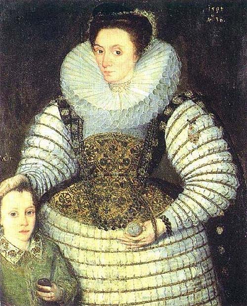
Sir
Francis Walsingham granted Bradford Manor in 1576
|
 |
|
Frances
Walsingham given Manor of Bradford as part of her Wedding Dowry in 1584
by her father for her marriage to the famous poet, Sir Philip Sydney.
|
 |
|
Paul
Methuen purchased the Manor of Bradford in 1774
|
 |
|
In
1754 Edward Burcombe surveyed the Prebend Manor.This map is interesting
in that it was produced for the Dean and Chapter of Bristol who were given
530 acres in 1543 by King Henry VIII. It shows their land holdings and
includes a long strip of land with a pathway which forms the southern
boundary with the French Grass field. One can speculate that the path
and wall running along this ridge is ancient and formed a boundary between
the Prebend and Lay Manor. The reference book and a copy of the map can
be seen at Bristol Archives or viewed by clicking on: 1754_Survey
and 1754_map
of _Bradford on_Avon.I have attempted to adapt this map to show how
the area south of the River Avon was divided into sub manors well into
the 19th Century. The Lay manor centred on Barton Farm pssesses most of
the land,then followed by the Prebend Manor. The Hall Manor was often
refered to as the Duke of Kingston`s Estate after the owner in the 18th
Century. there were also some smaller areas owned by the Lisles, Hungerfords,
Shrapnells and Priory of Monkton Farleigh in St Margarets Street.
|
|
"French
Grass Ground"
|
| The
ground on which St Margaret's Villas were eventually to be built formed
part of a larger block known as "Avon Field". We are fortunate
that a detailed Rental Book (w.r.o. 2845/4) has survived from 1631 when
it was leased from the Earl of Clanricard by Francis Lucy. French Grass
Ground may have been the 5 acre field detailed as a "Tineing in part
of Avon Field" or part of the larger 65 acre Avon Field. |
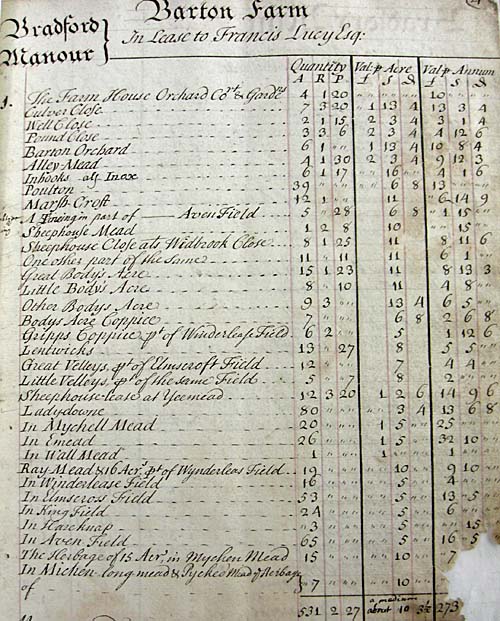 |
| The
Rental List for Barton Farm (w.r.o.
2845/3) for
the year 1631 when Francis Lucy was leasing Barton Farm from the Earl of
Clanricard. French Grass Ground may have been the 5 acre field detailed
as a "Tineing in part of Avon Field" or part of the larger 65
acre Avon Field. |
| This
is too early for the name "French Grass" as this crop often known
as Sainfoin, only came to this country in 1661 at about the same time as
turnips, the two together making a welcome addition to winter fodder. Grown
extensively in the 18th century by 1841 only one small field named French
Grass remained, though probably it was linked at one time to the larger
field. The extensive Avon Field occupied the area bounded by St Margaret's
Hill and the Trowbridge Road and its name still survives in the title of
a road. The 1754 Burcombe Map below clearly shows the field to be known
as "French Grass Ground", within which is a strip running parallel
to the row of houses forming St. Margaret's Place. |
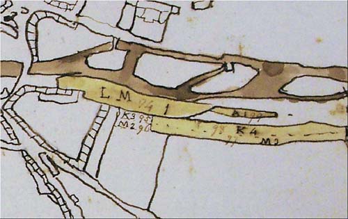 |
1754
map now in Bristol Record Office detailing part of the lands owned by the
Diocese of Bristol. Within the green area is K3 (95) which is described
as a Small Piece on Morgan's hill (38 perches)whose tenant in 1754
was Grace Taplin and by 1773 the Rev Benjamin Richardson. The other reference
M2 (96) described as an Open Piece on Morgan's (St. Margaret`s Hill)
was tenanted Robert Halliday in 1754 and James Hudson (1773).
Robert Halliday is the largest tenant renting over 3 acres in Bridge Street.
He probably lived in what is now the Bridge Tea Rooms as the same family
is known to have built the house in 1675 and the initials of Anslem and
Richard Halliday with the date can still be seen above the right hand dormer
of the building. In
time a row of small cottages (tithe nos. 501, 4, 5, 6) were to be built
on "the small piece on Morgan's Hill" which can be clearly seen
on the Tithe Map. Amazingly these were all demolished and only sections
of walls and foundations below the gravel by the scouts hut can be seen
today. |
It
is this strip of ground which was to reveal the history of this area in
the 18th Century. A lease was given by Lady Powlett, owner of the Lay Manor
(Barton Farm) in 1722 for a garden between those of Thomas Bush and James
Willett which formed part of the "French Grass Ground". James
Willett was a Drugget Maker living in St Margaret's Place and in his will
of 1731 mentions "all that of my other little garden lying and being
in the front of my said Dwelling House which I hold by Indenture of lease
granted by the honorable Ann Wright and Lady Powlett". Thomas Bush
was a wealthy Clothier who in his will of 1744 leaves to his son Samuel-
"all that my Garden Ground lying before the
two last mentioned messuages in Bradford" The gardens still exist
today with a common footpath then known as "Bush's Alley" separating
them from the row of houses. |
 |
| Both
James Willet and Thomas Bush are referred to in a deed of 1741 as owning
a brew house in the area. In the Duke of Kingston's Rentals for the year
1752 held at Nottingham University there is another reference to French
Grass Field as follows: "part of a parcel enclosed with other land
of Mr. Threshers & Robert Harvey called "French Grass Ground"
- 2 acres and a parcel on Morgan's (St Margaret's) Hill butting on W. Halliday's
- 1 acre". |
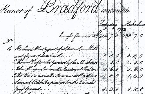 |
| The
Document above shows that Samuel Bethel was renting a piece in Smith's "French
Grass Ground" for 10s. in the year 1773. |
| It
would therefore seem that the French Grass Ground extended to St Margaret's
Place and a strip was subdivided into gardens that were originally leased
from Barton Farm by the owners of the houses. |
 |
|
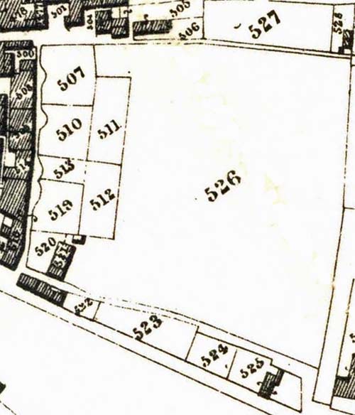
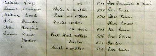
The 1841 Tithe Map shows these plots as nos. 507-520
with the ownership now with the houses. Unfortunately it only shows the
French Grass Ground (526) as a field, but in fact it formed a large number
of allotments which were let to town folk by Sir John Cam Hobhouse, the
owner of Barton Farm. |
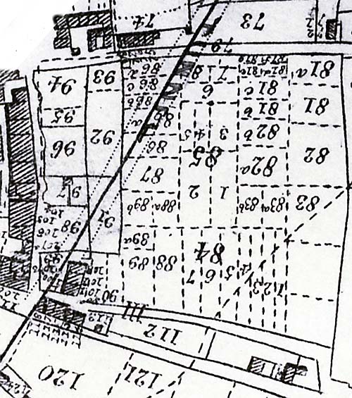 |
A clearer picture of the tenants is shown in the later 1845 map commissioned
by the Somerset, Wilts and Weymouth Railway company before they purchased
the ground they needed for their proposed railway line. A study of the tenants
shows them scattered throughout the town, often from the same families.
Of special interest is plot 86a on which St. Margaret's Villas was to be
built. The tenant was John Holloway, who is described as a Gardener in the
1841 Census. He lives for many years in a small terrace house towards the
top of No Where's Lane on St Margaret's Hill with his wife and 9 children.
No doubt his allotment was a merciful release from the squalor of his house
which was eventually condemned as a slum and demolished with the
others at the end of the 19th century.
|
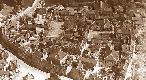 |
| An
early photograph showing the mass of houses and workshops on St. Margarets
Hill. Many of the occupants living in such small cramped conditions were
able to escape to their allotments which formed the "French Grass Ground"
close by. One of these was John Holloway, who is described as a Gardener
in the 1841 Census and rents the strip of land on which St Margarets Villas
was to eventually be built.Prior to 1690 there were a few isolated buildings
south of the river. But with the boom in the Wool Trade at the end of the
17th Century the area near the bridge was to be developed, especially by
Zachariah Shrapnell whose father Henry had earlier aquired a large area
of St. Margrets Hill. |
 |
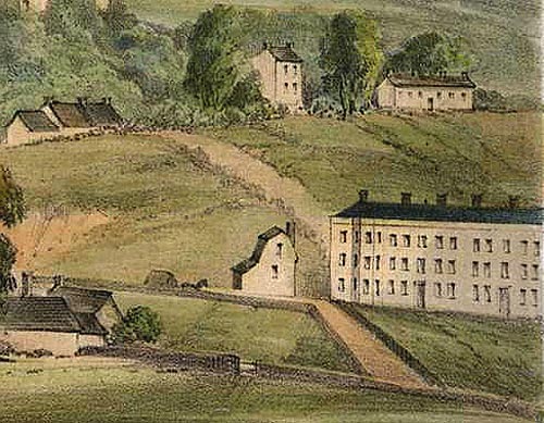
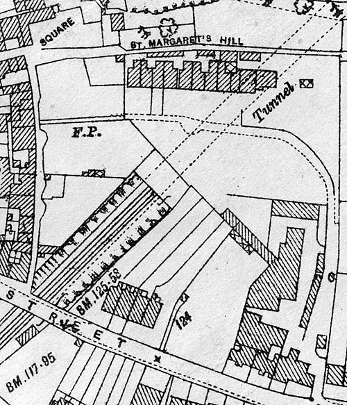
| This
view of the Station buildings in 1850 shows St Margaret`s Hill rising above
them through which Brunel was to bore his tunnel. Although everything was
finished it was not opened until February 2nd, 1857. |
| The
impact of the Railway on French Grass Ground |
Prior
to 1845 French Grass Ground would have been covered with a number of small
allotments. But in that year the Wilts, Somerset & Weymouth Railway
commissioned a survey of the area that they intended running their railway
line through. It can still be seen in the Wiltshire Record Office and is
more detailed than the Tithe Map. They were to purchase a large swathe of
buildings and land including "French Grass Ground" from Sir John
Cam Hobhouse. The earliest attempt to link Bradford with a railway network
was the Great Western way back in 1832, and the original map and reference
book still survive. It is astonishing to think that by 1848 in a period
of less than 3 years all the construction was finished. This included Station
buildings, Good Shed and Bridges over the roads as well as the river.
|
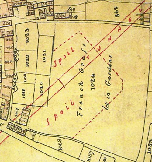 |
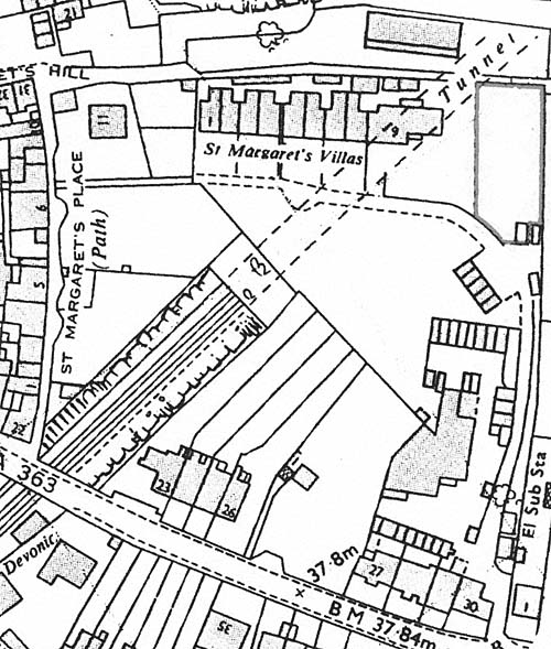
| A
Map by George Ashmead c. 1848, which has been amended to show the route
of the Tunnel under "French Grass" which is described as "let
in Gardens". It is also interesting in that it shows that the Spoil
from the workings was to be laid above on the field and the group of cottages
that were to go at the bottom of St. Margaret`s Place. |
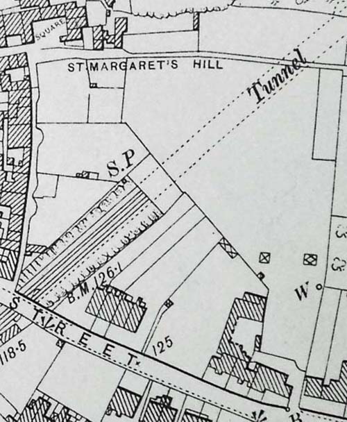
| But
it was the Tunnel under St Margaret's Hill linking it with Bridge Street
and the River Avon that was to test Brunel's ingenuity. A contemporary map
shows the spoil from it being placed on "French Grass Ground".
No doubt the stone that came out was used for building as later Albert Long
was to quarry from the same hill. Two groups of cottages at the junction
of St Margaret's Place and St Margaret's Street were lost as were many other
buildings including the Poor House and Cross Keys Tavern. After
all this,The Wilts. Somerset & Weymouth Railway ran into financial difficulites
and were unable to finish the stretch from Bradford to Bathhampton. It was
not until February 2nd 1857 that the new owners, the Great Western Railway
Company were able to finish the project and open the line that would link
Bradford on Avon to the railway network. |
 |
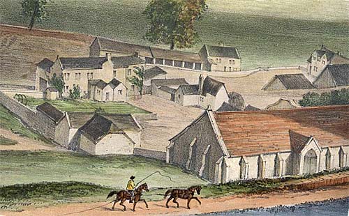
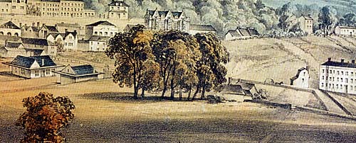
| Mrs
Elizabeth Tackle's Print of 1850 acts as a snapshot of the scene. The viewpoint
is from what is today Victory Field. On the left is the Timber Yard on the
Frome Road for the Duke of Kingston's Plantation which stretched down to
the river. Junction Road cuts through an empty field on to the Trowbridge
Road. The unusual tower shaped building was later to be incorporated into
Albert Villa and the long imposing terrace ( 1-5 Trowbridge Road) had recently
been completed by the Cadby`s . Behind these buildings can be seen the strip
gardens that went back to the path called St. Margaret`s Hill. The track
going up the hill still survives and is now the assess to St. Margaret's
Villas through Long`s Yard. The buildings on the horizon are shown in contemporary
maps along the path linking St Margaret's Hill, but have long since been
demolished. You can just see the large escarpment into the hill which in
turn would be lined with stone and bricks as the entrance to the tunnel.
|
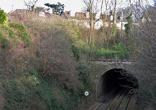 |
| The
Tunnel built in 1848 which enters a short distance from the Railway Station
and emerges by the River Avon in Bridge Street. St. Margaret`s Villas can
be seen above the tunnel. |
 |
|
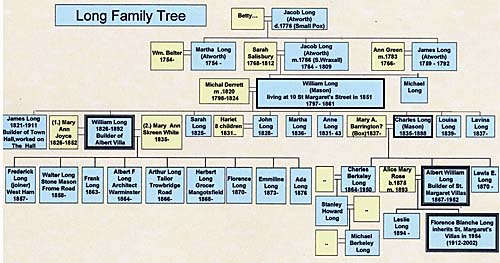
The family tree for the Long`s. To see larger version of this click on the
image above. |
| William
Long's purchase of French Grass Ground in 1858 |
| William
and Michal Long are shown as members of the Congregational Church in St
Margaret's Street from 1826. in the 1861 Census they are living at 10 St
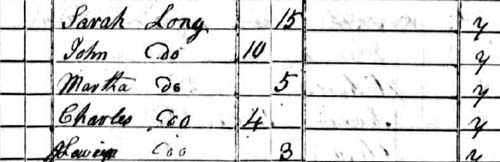
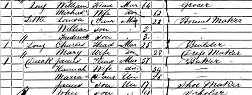
Margaret's Street next to their son Charles. They had four sons, James,
William, John and Charles all of whom became builders or carpenters in Bradford.
The eldest James, went on to build the imposing Town Hall in 1854, Belcombe
Place and also worked on the restoration of "The Hall" for Stephen
Moulton. He lived at Ferndale in St Margaret's Street near his brother William. |
 |
 |
|
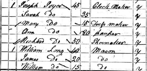
The 1841 Census shows the Joyce and Long Families renting 6 and 7 St Margaret`s
Street from General Henry Shrapnel. |
| William
was born in Bradford on Avon in 1826 and for much of his childhood lived
at 7 St Margaret's street where the 1841 Census describes his father as
a Mason (builder). Joseph Joyce, a Clock Maker occupied the adjoining property
with his wife and daughter Mary Ann. Six years later he was to marry Mary
Ann and live in a house in front of the United Church in Beazor Street (now
part of St Margaret's Street). Sadly she was to die in 1852 and he later
married Mary Skreen White from Broughton Gifford and they were to have 9
children. His fortunes as a builder changed dramatically when he saw the
potential of the open field that was "French Grass Ground" and
was able to buy it and other plots of land from the Great Western Railway
Company in the year after they had opened the Station in 1857. |
 |
 |
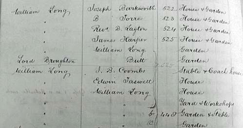 |
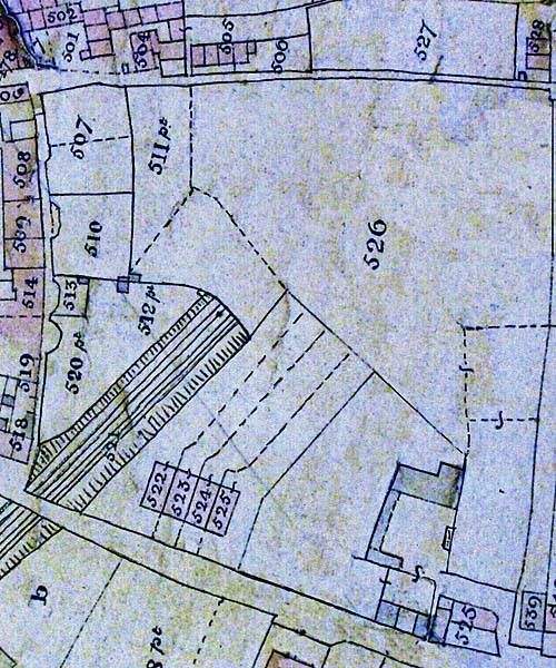
| The
Map produced by George Ashmead of Bristol in 1864. On the 8th November 1858
the Great Western Railway Company sold off the French Grass Field to William
Long, the builder. Within 5 years he had built the Victoria Terrace (tithe
no.`s 522-525) facing on to St. Margaret`s Street and also the Workshops
standing until recently and still known as Long`s Yard. The map shows that
the Albert Terrace was still to be started and part of the building (525)
was incorporated into its construction of the adjoining Albert Cottage.
It would seem William was already living in this house with his family at
the time. He is also shown as owning a small cottage on St Margarets Hill
which runs along the top of French Grass Ground. The map shows a large concentraion
of cottages (501- 528) here which have since disappeared. |
| By
1864 he had built first Victoria and later Albert Terrace. He went on to
build an impressive house for himself on the end of this terrace which still
bears the name of Albert Cottage. Immediately behind he constructed a number
of workshops. But he kept back most of the former French Grass Ground for
his fine Gardens which can be clearly seen with Glasshouses in the large
scale Ordnance Survey Map for 1886. He is known to have built a number of
properties in the St Margaret's Street area and also New Mills in Silver
Street. |
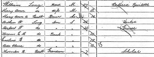 |
| The
1891 Census for Bradford on Avon shows William Long. aged 67 living with
his wife Mary Ann, at Albert Cottage. Two of his sons are living with him
and are shown as a tailor and grocer. It was to his nephew Albert William
that his business was to descend. |
 |
| Victoria
Terrace built by William Long soon after purchasing the French Grass Field
from The Great Western Railway Company. |
 |
|
Albert
Terrace built by William Long in 1864
|
 |
|
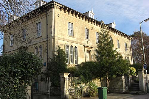
Albert
Cottage was where William Long was to live with his family for most of
his life. Behind it were workshops and extensive gardens.
|
| Though
William Long had 9 children, it seem strange that none of then were to continue
in the family business. Walter Long is shown in an 1890 directory as Stone
Merchant, builder and contractor at 3 Iona Terrace, and his brother Arthur
as a Tailor in the same year at 33 St. Margaret's Street. Albert went on
to be a successful architect in Warminster, Frederick moved to West Ham
in London as a Joiner and Herbert to Mangotsfield as a Grocer. |
 |
| The
Ordnance Survey Map of 1886 showing Albert Terrace completed with extensive
workshops behind them. There was also a tunnel into a quarry. The 1881 Census
shows William living in Albert Cottage and his brother James another builder
living at 1 Victoria Terrace.Most of the area known as French Grass Field
appears to be an extensive garden. |
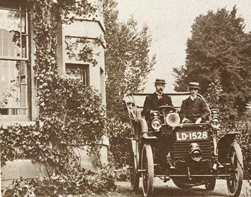 |
| Albert
William Long at the wheel of his Germain car in the grounds of the house
now Known as Little Underwoods on the Frome Road, c. 1912 |
|
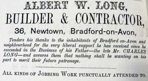
Albert
William Long's purchase of "French Grass Ground" in 1901
|
|
Charles
Long had workshops at the rear of 6-7 St Margaret's Street and briefly
occupied 10 St Margaret's Street. He was later to have his builders yard
at 36, Newtown and is described as a Quarry Master and Builder living
on the Woolley Road in 1881 Census. His son Charles Berkely and Albert
William are also shown living there . When Charles dies in 1888 at the
early age of 53,Albert takes on his father`s business
|
 |
| 1861
Census for Bradford on Avon shows Charles Long, father of Albert Long ,
aged 25 as a Builder living at 11 St. Margaret`s Street (now Green Tree
Health Centre). Next Door at no 10 ( Le Dolce Vita Restaurant) was his father
William described as a Grocer. |
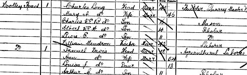 |
| 1881
Census for Bradford on Avon shows Charles Long, father of Albert Long, living
on the Woolley Road. He is described as a Builder and Quarry Master. |
 |
| The Ordnance
Survey Map of 1901 with few changes from the earlier map.Though this was
the year in which Albert Long was to purchase the remainder of "French
Grass Ground" for £1,000 from his Aunt Mary. |
 |
|
as is shown
in an advert displayed above of the same year. He marries Alice Mary Rose
in 1893 and the following year they have a son, Leslie, but sadly he was
to die. In 1901 they are shown as living at 46 Newtown near to his builders
yard. This was to be the year when he was to borrow £1,000 to buy
out his Aunt Mary Ann Long`s properties and land in St. Margaret's Street. |
 |
|
The 1902 directory
shows Albert living next to his aunt at 32 St. Margarets Street ( Albert
Villa).
|
|
|
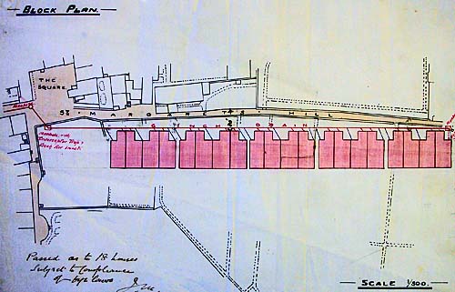
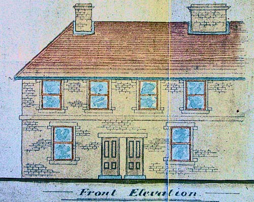
| The
Deed has survived and the accompanying map clearly shows that this included
the large garden at the rear of Albert Villas. Almost immediately he got
to work on submitting plans for a terrace of 20 houses to be built at the
top of the gardens along the boundary with St. Margaret's Hill. |
 |
|
A
close up of the proposed front elevation from the plans that are now held
at the Wiltshire Record Office.
|
 |
|
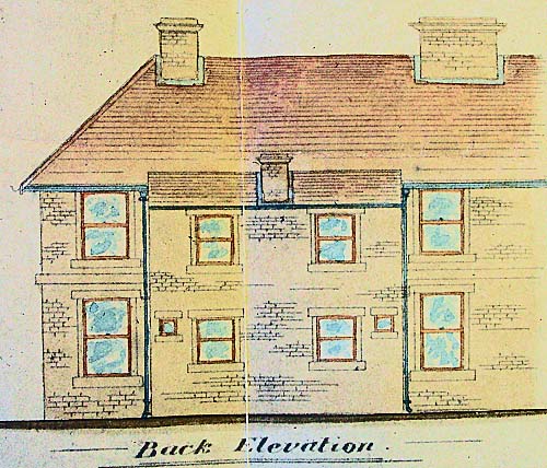
The Back Elevation
|
 |
|
The
view of 1-5 St. Margarets Villas c. 1918 with Albert Long proudly sitting
in the garden of no. 5.
|
 |
|
A close up of the photograph above showing Albert Long sitting in the
garden of no. 5 St Margarets Villas
|
 |
|
Builders
finishing off Albert Long`s new house - French Grass, at the end of the
terrace in 1918.
|
 |
|
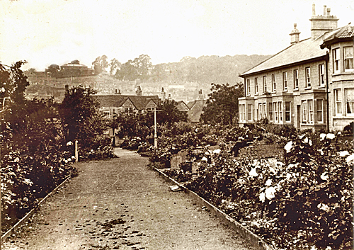
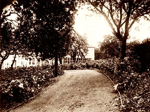
The
pathway that leads to St Margaret`s Villas in 1918. French Grass House
can be seen in the distance.
|
 |
|
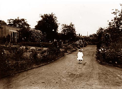
Frances,
daughter of Albert Long on the path outside St Margaret`s Villas in 1918
|
| But
in the end he was to complete only the first block of four by 1907 with
the next block of four being occupied the following year. He is shown as
living in the last house number 8. |
 |
|
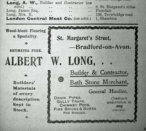
Advert
for Albert Long, Builder for 1910 showing him living at 8 St. Margarets
Villas.
|
| The
next phase of building work is in 1911 when he adds a new room to his property.
Finally in 1918 he submits plans for a further extension to create a 5 bed
roomed house directly above the Railway Tunnel. It
is said that at the time he was demolishing the Lamb Inn by the Old Town
Bridge and re-used the stone from it on this house. By
then he has a 3 year old daughter Florence Blanche and some marvellous photographs
from that year have survived and show the young daughter in the fine gardens
surrounding the house. There are also images of Albert Long sitting in the
gardens of number 5 and workman finishing off no. 9 which he was to call
"French Grass House". An earlier photograph shows him driving
a Germain car in the grounds of the house known as Little Underwood's, off
the Frome Road. |
 |
|
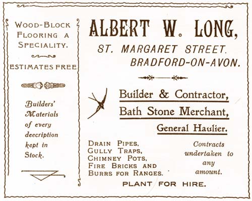
Advert
for Albert Long, Builder showing him at 6-7 St. Margarets Street.
|
| His
time there is short for in 1919 he buys the house most associated with the
family, 6-7 St Margaret's Street, where his father used to have his workshops.
He later sells this to the Rev Kirby Turner in 1929 and retires to Weymouth.
Where he lives on until 1952 , when he dies at the age of 85 leaving St.
Margaret's Villas and other property to his daughter Florence who continues
to live at Weymouth. |
 |
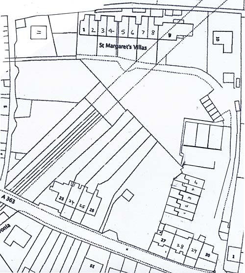
| The
Ordnance Survey Map of 1922 showing St Margaret`s Villas extending to no.9
which was called French Grass House. Albert lived here for a while but later
rented it out with the other houses. The buildings within Longs Yard had
become more extensive by then. |
|
A
Hundred Years of the Villas
|
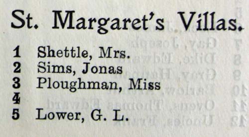
| When Albert
Long originally submitted his plans in 1905 it can be seen from the accompanying
drawings that he envisaged a long terrace of houses. For some reason this
was not carried out, even though it seems to have been passed at the time.
The following year Mrs Shattle, Jonas Sims and Alexander Laxen are shown
as occupying the first three houses in the rates book. The following year
no. 4 is still empty but George Lower, Rev. A. Rainey, Rev William Attwell
and Albert Long have taken the remainder of the new houses. Jonas Sims ,
a gardener was to stay there for 20 years, though Percy Smith, a rubber
worker lived for nearly 50 years at number 5. After Albert Long had moved
from the later built "French Grass House" it was occupied by A.G.
Williams who was the manager at the Midland Bank. J.A. Brown who ran the
Ironmongers (Alex. Browns) still trading today in Silver Street lived for
many years at number 8. C.W Rudman and later his wife were to live at number
3 for over 27 years. Altogether a study of the various houses shows that
over the century many people who came here stayed on for a long time. This
was all to change in 1983 when the owner, Florence Blanche, daughter of
Albert Long decided to offer the freehold of the houses to her tenants.
As a consequence many of the tenants were to sell their properties on. But
nowadays most of those living here have owned their properties for many
years and houses rarely come up for sale. This is mainly because it is felt
that it is a tranquil oasis in a busy town. |
| |
 |
| The
Ordnance Survey Map of 1993 showing some of the gardens that went with the
houses that form the Villas. Many of the tenants were to have the oppurtuntiy
to purchase the freeholds from Miss Florence Long who had inherited the
properties on the death of her father in 1953. The map also shows the garages
that were built near Longs Yard to ease the difficulty of getting cars near
to the houses.The Villas have two additional properties nos. 10 and 11 built
in former gardens at both ends of the terrace. |
 |
| The
Ordnance Survey Map of 2007 showing the former delapidated workshops in
Longs Yard replaced with Dajam Terrace - a row of delightful cottages. Above
them on the map are new built workshops. |
 |
|
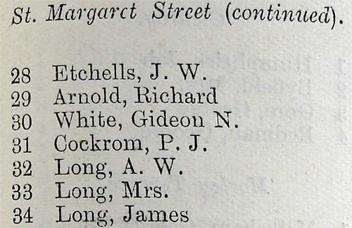
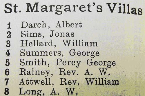
List
of Occupiers in 1908
|
 |
|
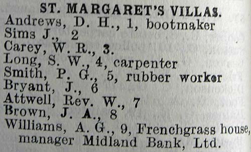
List
of Occupiers in 1912
|
 |
|
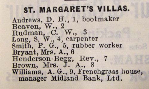
St
Margaret`s Villas 1925
|
 |
|
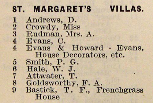
St
Margaret`s Villas 1939
|
 |
|
St
Margaret`s Villas 1951
|
 |
|
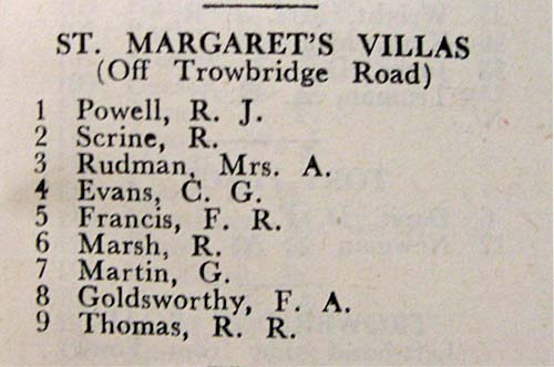
St
Margaret`s Villas 1963
|
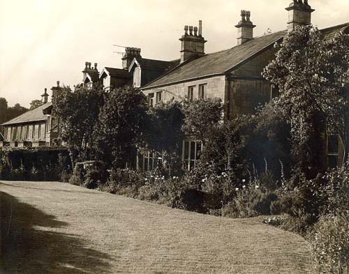 |
|
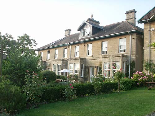
"French
Grass House" forming part of St Margaret`s Villas in
1970
|
 |
|
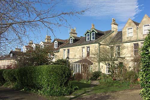
"French
Grass House" forming part of St Margaret`s Villas today
|
 |
|
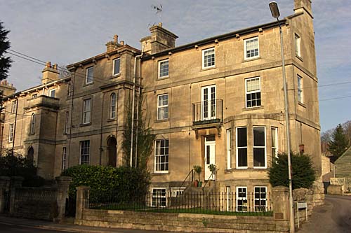
1-
5 St Margarets Villas today
|